urban landscape

Favela Night Lights, Rio de Janeiro Brazil

Favela Night Lights, Rio de Janeiro Brazil
A mesmerizing nocturnal view of Rio’s hillside communities alive with glowing windows and vibrant urban energy.

The favelas of Rio de Janeiro are among the most densely populated and visually striking urban communities in the world. When night falls, these hillside settlements transform into a breathtaking tapestry of lights—thousands of windows glowing in warm oranges, cool blues, and electric greens against the darkness. This nighttime perspective reveals not poverty or despair, but the resilience, creativity, and life force of communities where millions of Brazilians call home. The ‘Favela Lights’ capture a moment of raw urban beauty that challenges stereotypes and celebrates the vibrant humanity that thrives within these neighborhoods.

Highlights

  • Stunning nocturnal aerial views showcasing thousands of illuminated windows creating a mosaic of color and life
  • A authentic perspective on Rio’s urban landscape beyond the famous beaches and tourist zones
  • The interplay of warm golden lights contrasting with cool blue neon, reflecting the diversity of the community

What to Do

  • Take a guided favela tour during daylight to understand the community’s culture, art, and history responsibly
  • Visit viewpoints like Mirante da Lapa or Convento de Santo Antônio for elevated city views
  • Explore local art galleries, street art, and cultural initiatives celebrating favela creativity
  • Experience live music and local cuisine at community venues

Best Time to Visit

Year-round, though the dry season (May-September) offers clearer skies and better visibility for night photography

Getting There

Fly into Tom Jobim International Airport; most favelas are accessible via local buses, taxis, or organized tours from central Rio

Visitor Tips

  • Always use licensed guides or official tour operators when visiting favelas for safety and cultural respect
  • Visit during daylight hours on your first trip to understand the community’s daytime character
  • Bring a good camera with night mode capability to capture the atmospheric lighting
  • Respect residents’ privacy and avoid photographing people without permission

Nearby

  • Christ the Redeemer statue and Corcovado mountain viewpoint
  • Sugarloaf Mountain cable car
  • Copacabana and Ipanema beaches
  • Lapa historic district and nightlife

The lights of Rio’s favelas tell stories of resilience, community, and vibrant human spirit. This nocturnal landscape invites visitors to look beyond preconceptions and discover the authentic heart of Brazil’s most iconic city—a place where millions live, love, work, and celebrate life against a stunning backdrop of urban lights and hillside topography.

Location Map

Favela Night Lights, Rio de Janeiro Brazil Read More »

Singapore Skyline & River, Central Business District Singapore

Singapore Skyline & River, Central Business District Singapore
A stunning urban landscape where futuristic skyscrapers meet vibrant riverside culture along the heart of Singapore’s CBD.

The Singapore skyline is one of Asia’s most iconic and dynamic urban landscapes, showcasing a perfect blend of modern architecture and bustling waterfront life. Dominated by gleaming high-rise towers and punctuated by the historic Singapore River, this view captures the essence of Singapore’s transformation into a global financial hub. The skyline reflects the city-state’s remarkable development over decades, from a colonial trading port to a gleaming metropolis that seamlessly integrates commerce, culture, and green spaces.

This vantage point along the Singapore River reveals the city’s characteristic harmony between progress and tradition. The colorful heritage buildings and bustling river markets visible in the foreground contrast beautifully with the soaring contemporary towers, creating a visual narrative of Singapore’s evolution. The overcast tropical sky adds drama to the scene, highlighting the city’s subtropical climate and vibrant energy.

Highlights

  • Iconic modern skyscrapers including Marina Bay’s distinctive towers and the distinctive tall cylindrical buildings
  • Singapore River with its active boat traffic and historic waterfront character
  • Vibrant riverside markets and colorful traditional shophouses creating cultural contrast
  • World-class financial district housing major international banks and corporations
  • Perfect urban-nature balance visible from strategic viewpoints throughout the city

What to Do

  • Walk along Singapore River and explore the riverside promenade for photo opportunities
  • Visit nearby Marina Bay attractions including Marina Bay Sands and ArtScience Museum
  • Explore Boat Quay and Clarke Quay for restaurants, bars, and heritage experiences
  • Take a river cruise to experience the skyline from the water
  • Visit museums and cultural sites in the surrounding CBD area

Best Time to Visit

December to February offers cooler, drier weather ideal for exploring the waterfront and enjoying outdoor activities without intense heat.

Getting There

Singapore is easily accessible via Changi Airport, one of Asia’s busiest hubs. The MRT (Mass Rapid Transit) system efficiently connects the airport to the CBD. Most riverside viewpoints are within walking distance of major MRT stations like Raffles Place or Marina Bay.

Visitor Tips

  • Visit early morning or late afternoon for the best lighting and less crowded conditions for photography
  • Bring sun protection and stay hydrated due to Singapore’s tropical heat and humidity
  • The riverside promenade is best explored on foot to discover hidden gems and local eateries
  • Consider a guided river tour to learn about Singapore’s maritime history
  • Visit during weekdays to avoid weekend crowds at popular viewpoints

Nearby

  • Marina Bay Sands Hotel and observation deck for elevated skyline views
  • Merlion Park, Singapore’s most iconic landmark
  • Gardens by the Bay with its futuristic Supertree Grove
  • ArtScience Museum at Marina Bay Sands
  • Raffles Hotel, a historic luxury landmark

The Singapore skyline stands as a testament to human ambition and urban planning excellence. Whether you’re a photography enthusiast, architecture lover, or simply curious about one of the world’s most successful modern cities, the skyline and riverside offer an unforgettable experience. Come witness the harmonious blend of innovation and tradition that makes Singapore a must-visit destination for travelers seeking to understand the future of urban development.

Location Map

Singapore Skyline & River, Central Business District Singapore Read More »
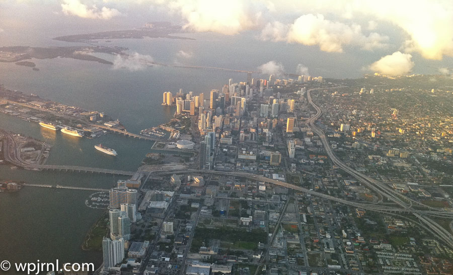
Downtown Miami Aerial View, Florida USA

Downtown Miami Aerial View, Florida USA
A stunning metropolis where gleaming skyscrapers rise above sparkling waterways and vibrant neighborhoods.

Downtown Miami is the vibrant heart of South Florida’s largest city, a dynamic urban landscape where modern architecture meets tropical climate. This aerial perspective reveals the city’s impressive skyline featuring distinctive high-rises, major cruise ships docked in the port, and the intricate network of waterways that define Miami’s geography. From above, you can appreciate how downtown Miami seamlessly blends commerce, culture, and coastal beauty into one of America’s most visually striking metropolitan areas.

The cityscape showcases Miami’s transformation into a global financial and cultural hub, with the iconic downtown core surrounded by residential neighborhoods, major transportation arteries, and natural green spaces. The proximity to Biscayne Bay and the Atlantic Ocean makes this city uniquely positioned at the intersection of urban development and natural waterfront beauty. This aerial view captures why Miami has become one of the most sought-after destinations for business, tourism, and residential living in the United States.

Highlights

  • Iconic downtown skyline with modern high-rise buildings and distinctive architecture
  • Biscayne Bay with cruise ships and maritime activity showcasing Miami’s major port status
  • Clear view of transportation infrastructure including highways and bridges connecting the city
  • Contrast between urban development and natural landscape with parks and green spaces
  • Strategic coastal location at the gateway between mainland Florida and the ocean

What to Do

  • Explore downtown Miami’s financial district and contemporary art galleries
  • Visit the Miami Cruise Port to see massive cruise ships or embark on Caribbean voyages
  • Enjoy waterfront dining and shopping at Bayside Marketplace
  • Take a walking tour of historic architecture and public art installations
  • Visit nearby neighborhoods like Wynwood for street art and cultural venues
  • Relax at South Pointe Park with panoramic bay and ocean views

Best Time to Visit

November to April offers comfortable temperatures and lower humidity, making it ideal for exploring downtown Miami and enjoying outdoor activities without the intense summer heat.

Getting There

Miami International Airport (MIA) is 20 minutes from downtown via taxi or ride-share. Public transportation includes Metrorail trains, Metromover automated system, and bus services. Interstate 95 provides major highway access.

Visitor Tips

  • Use the Metromover free automated transit system for easy downtown navigation
  • Book waterfront activities and dinner reservations in advance during peak season
  • Bring sunscreen and stay hydrated—Miami’s tropical sun is intense year-round
  • Explore downtown at sunset for spectacular views of the skyline reflecting on the water
  • Nearby South Beach is only 20 minutes away for beach experiences

Nearby

  • South Beach and Miami Beach with pristine sandy shores
  • Wynwood Walls featuring massive colorful street art murals
  • Vizcaya Museum and Gardens showcasing Italian Renaissance-inspired architecture
  • Miami Design District with upscale shopping and galleries
  • Little Havana neighborhood for Cuban culture and cuisine

Downtown Miami’s aerial splendor reveals why this city captivates millions of visitors and residents alike. The combination of impressive architecture, thriving commerce, cultural diversity, and tropical waterfront location creates a uniquely compelling destination. Whether you’re visiting for business, culture, or simply to experience one of America’s most dynamic cities, downtown Miami offers unforgettable perspectives from both the sky and the ground. Plan your visit today to discover why Miami continues to evolve as a world-class metropolitan destination.

Location Map

Downtown Miami Aerial View, Florida USA Read More »
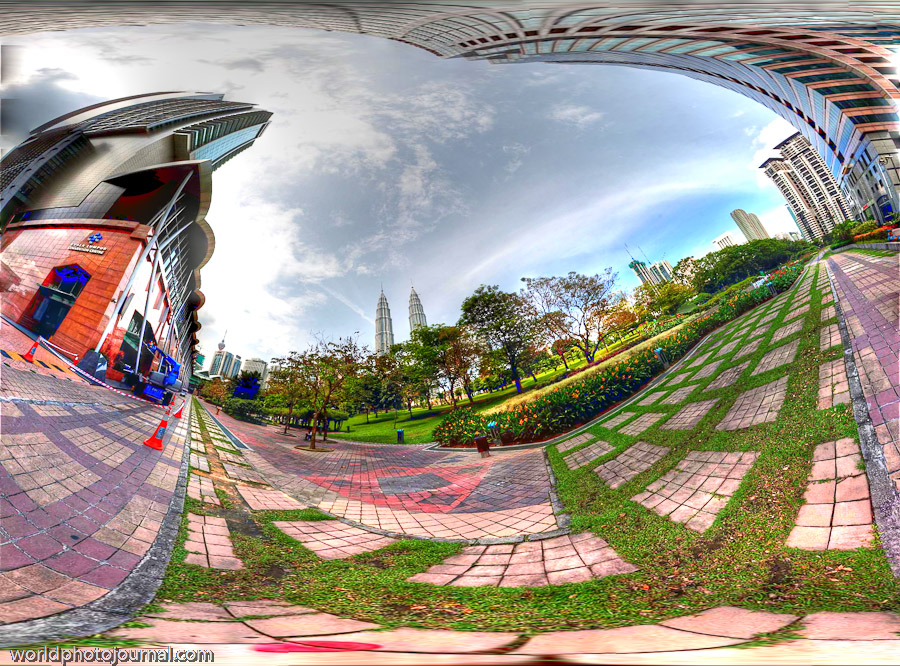
KLCC Park & Petronas Twin Towers, Kuala Lumpur Malaysia

KLCC Park & Petronas Twin Towers, Kuala Lumpur Malaysia
A stunning urban oasis featuring the iconic Petronas Twin Towers and lush gardens in Malaysia’s vibrant capital city.

KLCC Park is Kuala Lumpur’s most iconic destination, offering breathtaking panoramic views of the city’s gleaming skyline dominated by the world-famous Petronas Twin Towers. This 20-hectare park beautifully blends modern architecture with natural landscaping, creating a serene escape in the heart of the bustling metropolis. The park’s meticulously maintained grounds, verdant gardens, and architectural landmarks make it a must-visit destination for travelers seeking to experience the perfect fusion of nature and urban development.

Taken from the Traders Hotel, this panoramic perspective captures the essence of modern Kuala Lumpur, showcasing the dramatic interplay between contemporary skyscrapers, manicured gardens, and the sprawling cityscape. The wide-angle view reveals the park’s sophisticated paving patterns, vibrant landscaping, and the towering presence of the Petronas Towers in the distance, creating an unforgettable visual experience.

Whether you’re a photography enthusiast, architecture lover, or nature admirer, KLCC Park offers countless opportunities to witness one of Asia’s most impressive urban landscapes while enjoying peaceful moments surrounded by carefully curated greenery.

Highlights

  • Petronas Twin Towers – iconic 452-meter twin skyscrapers with an elevated skybridge offering panoramic city views
  • KLCC Park – 20-hectare beautifully landscaped garden with jogging paths, water features, and open spaces
  • Aquaria KLCC – Southeast Asia’s largest aquarium located within the complex
  • Petronas Twin Towers Skybridge – walk 170 meters above ground between the two towers for breathtaking vistas
  • Suria KLCC Shopping Mall – world-class shopping and dining destinations

What to Do

  • Visit the Skybridge observation deck for 360-degree views of Kuala Lumpur’s skyline and surrounding regions
  • Stroll through KLCC Park’s scenic pathways, enjoying the landscaped gardens and water features
  • Explore Aquaria KLCC’s diverse marine life exhibits and interactive displays
  • Shop and dine at Suria KLCC’s premium retail and restaurant outlets
  • Capture stunning photographs during golden hour from various vantage points throughout the park and complex

Best Time to Visit

December to February offers the most comfortable weather with lower humidity and temperatures around 22-32°C. The park’s landscaping is especially vibrant during the dry season, and the clearer skies provide excellent visibility for panoramic photography.

Getting There

The KLCC complex is easily accessible via the Kuala Lumpur Metro (LRT and MRT) with stations directly at KLCC. Taxis, ride-sharing services, and organized tours are readily available. The Traders Hotel is conveniently located at the site, offering direct access to the park and towers.

Visitor Tips

  • Book Petronas Twin Towers Skybridge tickets online in advance to avoid queues, especially during peak hours
  • Visit early morning or late afternoon for the best photography lighting and fewer crowds
  • Wear comfortable walking shoes as exploring the park requires substantial walking
  • Bring camera equipment with wide-angle lenses to capture the expansive panoramic vistas
  • Stay hydrated and use sunscreen due to Malaysia’s tropical climate

Nearby

  • Menara KL – alternative observation tower offering 360-degree city views
  • Merdeka Square – historic landmark and Malaysia’s oldest urban park
  • Bukit Nanas Forest Reserve – pristine rainforest within the city
  • Pavilion KL Shopping Mall – upscale shopping destination nearby

KLCC Park and the Petronas Twin Towers represent the pinnacle of modern Kuala Lumpur, showcasing the city’s remarkable transformation into a global metropolis. This iconic destination seamlessly blends architectural grandeur with natural beauty, offering visitors an unforgettable experience. Whether you’re ascending the Skybridge for breathtaking aerial perspectives, leisurely strolling through manicured gardens, or capturing stunning panoramic photographs, KLCC Park promises memories that will last a lifetime. Plan your visit today and discover why this remarkable destination captivates millions of travelers from around the world each year.

Location Map

KLCC Park & Petronas Twin Towers, Kuala Lumpur Malaysia Read More »
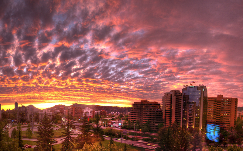
Las Condes Neighborhood, Santiago de Chile

Las Condes Neighborhood, Santiago de Chile
Experience dramatic sunsets over Chile’s modern skyline in the upscale neighborhood of Las Condes.

Las Condes is one of Santiago’s most prestigious and modern neighborhoods, known for its gleaming high-rise buildings, sophisticated dining scene, and vibrant urban landscape. Nestled against the backdrop of the Andes Mountains, this affluent district showcases contemporary architecture alongside tree-lined streets and parks. The neighborhood offers stunning vistas, particularly during sunset when the sky ignites in brilliant shades of orange, pink, and gold, creating an unforgettable natural display over the city’s impressive skyline.

Highlights

  • Dramatic sunset views over the modern skyline and Andes Mountains
  • Contemporary architecture and upscale residential high-rises
  • World-class restaurants, boutiques, and shopping centers
  • Well-maintained parks and green spaces throughout the neighborhood
  • Proximity to major cultural attractions and business districts

What to Do

  • Catch the sunset from a rooftop bar or viewpoint to witness the sky’s fiery transformation
  • Explore high-end restaurants and cafes featuring international and Chilean cuisine
  • Visit nearby museums and cultural centers including the Chilean Museum of Contemporary Art
  • Shop at upscale malls and boutique stores along Avenida Apoquindo
  • Enjoy evening walks through landscaped parks and plazas

Best Time to Visit

Year-round, though spring (September-November) and autumn (March-May) offer the most spectacular sunset displays with clearer skies. Summer (December-February) evenings are warm and pleasant for outdoor activities.

Getting There

Las Condes is easily accessible via Santiago’s Metro system (Lines 1 and 6), buses, or taxis. The neighborhood is centrally located within the metropolitan area, approximately 15-20 minutes from downtown Santiago.

Visitor Tips

  • Position yourself at a high vantage point or rooftop venue 30 minutes before sunset for optimal viewing
  • The air quality can affect sunset visibility; check local conditions beforehand
  • Bring a camera to capture the vivid colors and dramatic cloud formations
  • Many rooftop bars and restaurants offer sunset specials and viewing areas
  • Evening traffic can be heavy; plan your arrival time accordingly

Nearby

  • Parque Arauco shopping mall
  • Chilean Museum of Contemporary Art (MAC)
  • Cerro San Cristóbal viewpoint
  • Lastarria cultural neighborhood
  • Downtown Santiago (Centro)

Las Condes represents the modern face of Santiago, where contemporary urban sophistication meets natural beauty. The neighborhood’s stunning sunsets—painted across the sky in brilliant crimson and gold—offer a magical experience that perfectly captures the essence of Chile’s dynamic capital. Whether you’re dining at an upscale restaurant or simply standing in awe of nature’s daily spectacle, Las Condes invites you to witness the extraordinary beauty of Santiago at its most enchanting hour.

Location Map

Las Condes Neighborhood, Santiago de Chile Read More »

Scroll to Top