aerial photography

Aerial View of the Arctic Winter Landscape, Northern Canada

Aerial View of the Arctic Winter Landscape, Northern Canada
A hauntingly beautiful aerial glimpse of the frozen Arctic at twilight, where the moon rises over endless snow-carved mountains.

Captured from high above the Arctic Circle, this ethereal scene reveals the raw, untouched majesty of the polar north during the long winter twilight. Snow-covered ridges fan out like frozen veins across the landscape, while a luminous moon hangs in a deep cobalt sky — a moment frozen between night and day.

The Arctic in winter is a realm of extremes: sub-zero temperatures, perpetual blue hours, and a silence so vast it feels otherworldly. Seen from a passing aircraft, the landscape transforms into a surreal painting where shadow and light sculpt every peak and valley. It’s a fleeting glimpse of one of Earth’s last true wildernesses.

Highlights

  • Stunning blue-hour twilight that lingers for hours during Arctic winter
  • Moonrise over snow-covered mountain ranges seen from aircraft cruising altitude
  • Dramatic textures of glacial ridges and frozen valleys stretching to the horizon
  • Pristine, uninhabited polar wilderness rarely witnessed by human eyes

What to Do

  • Book a window seat on polar route flights between North America, Europe, and Asia for incredible aerial views
  • Join an Arctic expedition cruise to experience the frozen landscape up close
  • Visit Iqaluit or Yellowknife for guided winter excursions and aurora viewing
  • Try dog sledding or snowmobiling across the frozen tundra

Best Time to Visit

December through February offers the most dramatic blue-hour light and moonlit snowscapes, while March brings longer daylight for exploration.

Getting There

Most polar views are seen from transcontinental flights crossing the Arctic. To visit on the ground, fly into Iqaluit (YFB), Yellowknife (YZF), or via expedition cruise from Greenland or Svalbard.

Visitor Tips

  • Always request a window seat on northern long-haul flights for landscape photography
  • Bring a fast lens and high ISO capability — Arctic light is dim but magical
  • Dress in extreme-cold gear if visiting on the ground; temperatures can drop below -40°C
  • Check moon phase calendars to time your trip with a rising full moon

Nearby

  • Baffin Island and Auyuittuq National Park
  • Greenland’s eastern fjords
  • Ellesmere Island wilderness
  • Iqaluit, capital of Nunavut

There’s something profoundly humbling about witnessing the Arctic in winter — a landscape that feels untouched by time. Whether glimpsed from 35,000 feet or experienced on the frozen ground below, the polar north reminds us how vast, quiet, and wondrous our planet truly is.

Location Map

Aerial View of the Arctic Winter Landscape, Northern Canada Read More »
The Bund Aerial View, Shanghai China

The Bund Aerial View, Shanghai China
A breathtaking aerial perspective of Shanghai’s iconic skyline where the Huangpu River meets the futuristic Pudong district.

Captured from high above, this striking black and white aerial view showcases the dramatic contrast between Shanghai’s old and new — the historic Bund waterfront curving along the Huangpu River, and the towering skyscrapers of Pudong’s Lujiazui financial district reaching toward the sky. The monochrome treatment lends the cityscape a timeless, cinematic quality.

Shanghai is a city of staggering scale and ambition, and few vantage points capture its energy quite like this. From the dense forest of glass and steel towers in the foreground to the sprawling urban grid stretching to the horizon, the photograph reveals the breathtaking density and rapid evolution of one of the world’s great megacities.

The Bund itself, on the far side of the river, is a legendary stretch of colonial-era architecture that tells the story of Shanghai’s cosmopolitan past, while Pudong’s skyline embodies its bold, modern future.

Highlights

  • Sweeping aerial perspective of Shanghai’s Pudong skyline and the Huangpu River
  • Iconic skyscrapers including Jin Mao Tower and the Shanghai World Financial Center
  • Striking contrast between the historic Bund and ultramodern Lujiazui district
  • Dramatic black and white treatment that highlights architectural form and scale

What to Do

  • Stroll the Bund promenade for classic views of the Pudong skyline across the river
  • Ascend the Shanghai Tower or SWFC observation deck for panoramic city views
  • Take a Huangpu River cruise at sunset to see both sides of the city illuminated
  • Explore the colonial-era architecture and boutique hotels along the Bund
  • Visit Yu Garden and the surrounding old town for a taste of traditional Shanghai

Best Time to Visit

Autumn (September to November) offers the clearest skies, mild temperatures, and the best visibility for skyline photography.

Getting There

Shanghai is served by two major international airports — Pudong (PVG) and Hongqiao (SHA). The Bund and Lujiazui are both easily accessible via Shanghai Metro Lines 2, 10, and 14, or by taxi from anywhere in the city.

Visitor Tips

  • Visit the Bund at dusk to catch the skyline lighting up across the river
  • For the best aerial views, book an observation deck ticket in advance to skip queues
  • Use the Bund Sightseeing Tunnel or ferry to cross between the Bund and Pudong
  • Air quality can vary — check forecasts for the clearest viewing days

Nearby

  • Lujiazui Financial District
  • Nanjing Road shopping street
  • Yu Garden and Old Town
  • Shanghai Tower observation deck
  • Xintiandi entertainment district

Whether seen from a soaring observation deck or imagined from this stunning aerial frame, Shanghai’s skyline is a sight that lingers in the memory. Come witness the pulse of modern China where every tower tells a story of ambition, transformation, and the relentless rise of a global city.

Location Map

The Bund Aerial View, Shanghai China Read More »

Maldivian Airlines Dash 8 Flight Male to Kaadedhdhoo — Stunning Aerial Views of the Maldives Atolls

Experience breathtaking aerial footage of pristine Maldivian atolls and turquoise lagoons on this scenic regional flight from Male to Kaadedhdhoo.

Flying through the Maldives is a dream experience for any aviation enthusiast or tropical paradise lover. This video captures a spectacular journey aboard Maldivian Airlines’ Dash 8 turboprop, one of the most scenic regional routes in the world. As the aircraft climbs from Male International Airport, passengers are treated to a bird’s-eye view of the iconic Maldivian atolls — a mesmerizing landscape of emerald-green islands scattered across crystalline turquoise waters.

The Dash 8 is the perfect aircraft for island-hopping in the Maldives, offering excellent visibility from both sides of the cabin and a thrilling low-level flying experience. This flight to Kaadedhdhoo, located in the southern Gaaf Dhaal Atoll, is one of the most rewarding routes you can take in the Indian Ocean, showcasing the natural beauty that makes the Maldives one of the world’s most coveted travel destinations.

Whether you’re planning a trip to the Maldives, passionate about regional aviation, or simply love aerial photography, this video is an absolute must-watch.

Video Highlights

  • Stunning aerial views of multiple Maldivian atolls with pristine lagoons and white-sand islands
  • Takeoff and climb from Male International Airport with excellent cabin visibility
  • Real flight experience aboard the Maldivian Airlines Dash 8-300 turboprop (8Q-IAQ)
  • Bird’s-eye perspective of the intricate atoll geography and coral formations

What to Expect

  • Panoramic aerial photography of turquoise lagoons and emerald islands as seen from the aircraft
  • Realistic flight operations from one of Asia’s most scenic regional routes
  • Incredible cloud formations and tropical seascape views throughout the journey
  • Close-up perspectives of the Maldivian atolls that reveal why this destination is world-famous

Location

If you’ve ever dreamed of flying over the Maldives or want to experience the magic of regional aviation in one of the world’s most beautiful destinations, this video is essential viewing. The Dash 8’s intimate cabin experience combined with these unparalleled aerial views creates a truly unforgettable journey. Hit play and discover why the Maldives remains one of aviation’s most spectacular destinations.

Maldivian Airlines Dash 8 Flight Male to Kaadedhdhoo — Stunning Aerial Views of the Maldives Atolls Read More »

Mount Everest Aerial View, Nepal Himalayas

Mount Everest Aerial View, Nepal Himalayas
Experience the world’s highest peak from the sky with Buddha Air’s unforgettable mountain flights.

Mount Everest stands as the ultimate symbol of human ambition and natural grandeur, rising 29,032 feet above sea level in the heart of the Himalayas. Viewing this iconic peak from Buddha Air’s scenic flights offers an unparalleled perspective that ground-based expeditions cannot match. These carefully timed aerial journeys provide photographers and adventure seekers with stunning vistas of Everest’s snow-covered slopes, neighboring peaks, and the vast Himalayan range stretching across the horizon. Buddha Air’s Mount Everest flights depart from Kathmandu and offer one of the most accessible ways to witness this legendary mountain without the months-long commitment of a climbing expedition.

Highlights

  • Aerial views of Mount Everest’s north and south faces with pristine snow coverage
  • 360-degree panoramic vistas of the Himalayan mountain range including Lhotse, Nuptse, and Makalu
  • Professional mountain photography opportunities from pressurized aircraft windows
  • Early morning flights capturing golden light on the peaks with minimal cloud cover

What to Do

  • Book a scenic flight with Buddha Air departing from Tribhuvan International Airport in Kathmandu
  • Photograph Mount Everest and surrounding peaks from optimal aerial angles
  • Spot other major Himalayan peaks and identify geographical features from experienced pilots
  • Combine with Everest Base Camp trekking or other Nepal mountain adventures

Best Time to Visit

September to November and March to May offer clear skies and optimal visibility. October and April are peak months with the most reliable weather conditions and stunning photographic light.

Getting There

Fly from Kathmandu’s Tribhuvan International Airport with Buddha Air. Flights depart early morning (typically 6-7 AM) and last approximately one hour. Transfers from Kathmandu hotels are available.

Visitor Tips

  • Book flights in advance during peak season as they fill quickly
  • Arrive early and confirm weather conditions; flights may be rescheduled for safety
  • Wear warm layers despite pressurized cabin as temperatures at altitude remain cold
  • Bring a high-quality camera with fast shutter speed to capture clear mountain images through aircraft windows
  • Sit on the right side of the aircraft for the best Everest views during northbound routes

Nearby

  • Everest Base Camp Trek starting from Lukla
  • Kathmandu Durbar Square UNESCO World Heritage Site
  • Pashupatinath Temple in Kathmandu
  • Pokhara mountain town and Annapurna region

Mount Everest has captivated human imagination for centuries, and experiencing it from Buddha Air’s scenic flights is a transformative journey that combines comfort with awe-inspiring natural beauty. Whether you’re a serious mountaineer, passionate photographer, or simply a traveler seeking unforgettable memories, these aerial expeditions offer an intimate encounter with the world’s highest peak. The moment you witness Everest’s snow-crowned summit breaking through the clouds at dawn is an experience that will forever change your perspective on human achievement and the majesty of nature.

Location Map

Mount Everest Aerial View, Nepal Himalayas Read More »

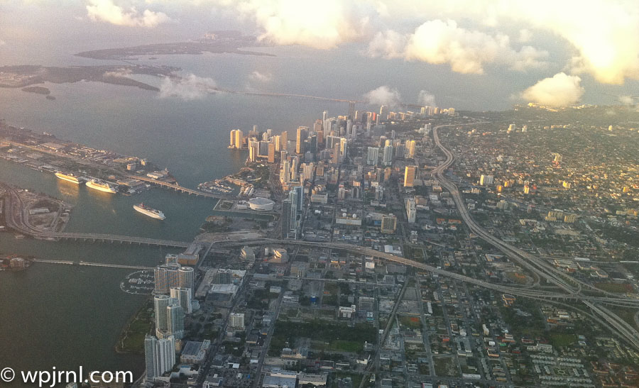
Downtown Miami Aerial View, Florida USA

Downtown Miami Aerial View, Florida USA
A stunning metropolis where gleaming skyscrapers rise above sparkling waterways and vibrant neighborhoods.

Downtown Miami is the vibrant heart of South Florida’s largest city, a dynamic urban landscape where modern architecture meets tropical climate. This aerial perspective reveals the city’s impressive skyline featuring distinctive high-rises, major cruise ships docked in the port, and the intricate network of waterways that define Miami’s geography. From above, you can appreciate how downtown Miami seamlessly blends commerce, culture, and coastal beauty into one of America’s most visually striking metropolitan areas.

The cityscape showcases Miami’s transformation into a global financial and cultural hub, with the iconic downtown core surrounded by residential neighborhoods, major transportation arteries, and natural green spaces. The proximity to Biscayne Bay and the Atlantic Ocean makes this city uniquely positioned at the intersection of urban development and natural waterfront beauty. This aerial view captures why Miami has become one of the most sought-after destinations for business, tourism, and residential living in the United States.

Highlights

  • Iconic downtown skyline with modern high-rise buildings and distinctive architecture
  • Biscayne Bay with cruise ships and maritime activity showcasing Miami’s major port status
  • Clear view of transportation infrastructure including highways and bridges connecting the city
  • Contrast between urban development and natural landscape with parks and green spaces
  • Strategic coastal location at the gateway between mainland Florida and the ocean

What to Do

  • Explore downtown Miami’s financial district and contemporary art galleries
  • Visit the Miami Cruise Port to see massive cruise ships or embark on Caribbean voyages
  • Enjoy waterfront dining and shopping at Bayside Marketplace
  • Take a walking tour of historic architecture and public art installations
  • Visit nearby neighborhoods like Wynwood for street art and cultural venues
  • Relax at South Pointe Park with panoramic bay and ocean views

Best Time to Visit

November to April offers comfortable temperatures and lower humidity, making it ideal for exploring downtown Miami and enjoying outdoor activities without the intense summer heat.

Getting There

Miami International Airport (MIA) is 20 minutes from downtown via taxi or ride-share. Public transportation includes Metrorail trains, Metromover automated system, and bus services. Interstate 95 provides major highway access.

Visitor Tips

  • Use the Metromover free automated transit system for easy downtown navigation
  • Book waterfront activities and dinner reservations in advance during peak season
  • Bring sunscreen and stay hydrated—Miami’s tropical sun is intense year-round
  • Explore downtown at sunset for spectacular views of the skyline reflecting on the water
  • Nearby South Beach is only 20 minutes away for beach experiences

Nearby

  • South Beach and Miami Beach with pristine sandy shores
  • Wynwood Walls featuring massive colorful street art murals
  • Vizcaya Museum and Gardens showcasing Italian Renaissance-inspired architecture
  • Miami Design District with upscale shopping and galleries
  • Little Havana neighborhood for Cuban culture and cuisine

Downtown Miami’s aerial splendor reveals why this city captivates millions of visitors and residents alike. The combination of impressive architecture, thriving commerce, cultural diversity, and tropical waterfront location creates a uniquely compelling destination. Whether you’re visiting for business, culture, or simply to experience one of America’s most dynamic cities, downtown Miami offers unforgettable perspectives from both the sky and the ground. Plan your visit today to discover why Miami continues to evolve as a world-class metropolitan destination.

Location Map

Downtown Miami Aerial View, Florida USA Read More »

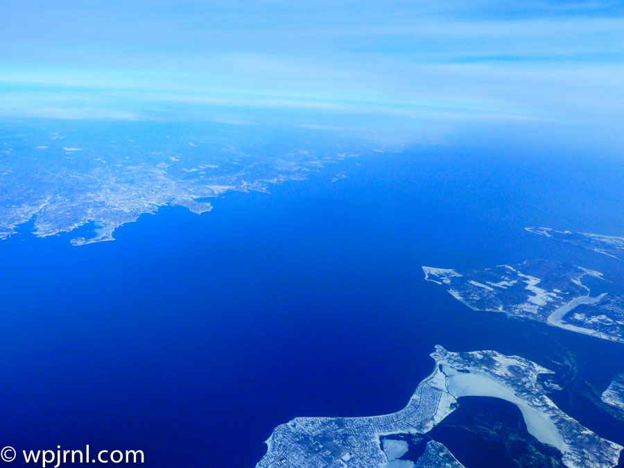
New York Aerial Winter Landscape, New York USA

New York Aerial Winter Landscape, New York USA
Witness the frozen beauty of New York’s archipelago and waterways from above during winter’s crisp season.

This stunning aerial photograph captures New York’s intricate geography during winter, revealing the complex network of islands, waterways, and coastal development that defines this iconic region. From thousands of feet above, the contrast between the deep blue waters and snow-covered land creates a breathtaking winter landscape. The view showcases the Hudson River, East River, and numerous islands that form the foundation of New York City’s unique metropolitan layout, frozen in time during the coldest season.

Highlights

  • Aerial perspective of New York’s frozen waterways and islands in winter
  • Clear visibility of the Hudson River and East River systems
  • Snow-covered landscapes contrasting with deep blue water
  • Bird’s-eye view of New York’s complex coastal geography

What to Do

  • Fly over New York City to capture aerial photography similar to this view
  • Visit observation decks like the Empire State Building or One World Observatory for elevated city views
  • Explore the islands and waterfronts by boat or helicopter tour
  • Experience winter activities across the city’s parks and outdoor spaces

Best Time to Visit

Winter (December to February) offers clear skies, snow-covered landscapes, and exceptional visibility for aerial photography

Getting There

Fly into one of New York’s three major airports: JFK, LaGuardia, or Newark. Helicopter tours depart from various locations in Manhattan.

Visitor Tips

  • Book helicopter or airplane tours early for the best aerial photography opportunities
  • Winter weather provides clearer atmospheric conditions for aerial shots
  • Dress warmly if taking open-door aerial photography flights
  • Visit during midday for optimal lighting conditions

Nearby

  • Manhattan skyline and urban landscape
  • Statue of Liberty and Liberty Island
  • Central Park winter scenery
  • Brooklyn Bridge and East River waterfront

Seeing New York from above transforms your understanding of this magnificent city. The aerial winter perspective reveals nature’s intricate artistry alongside human development, creating a humbling reminder of the scale and complexity of one of the world’s greatest metropolitan areas. Plan your aerial tour today and witness New York’s breathtaking geography from a perspective few experience.

Location Map

New York Aerial Winter Landscape, New York USA Read More »

Scroll to Top