hiking

Nagarkot Viewpoint, Himalayan Overlook Nepal

Nagarkot Viewpoint, Himalayan Overlook Nepal
A breathtaking mountain village offering panoramic views of the snow-capped Himalayan peaks across the Kathmandu Valley.

Perched at 2,175 meters (7,136 feet) above sea level, Nagarkot is one of Nepal’s most celebrated viewpoints, renowned for its stunning vistas of the Himalayan range. This charming hillside settlement overlooks the Kathmandu Valley and offers some of the clearest sightlines to distant snow-capped peaks, making it a favorite destination for trekkers, photographers, and nature enthusiasts. The village is dotted with prayer flags, traditional lodges, and peaceful trails that wind through rhododendron forests and terraced farmland. On clear days, visitors can spot peaks including Everest, Langtang, and Manaslu in the distance.

Highlights

  • Panoramic Himalayan views with visibility up to Mount Everest on clear days
  • Colorful Buddhist prayer flags strung across hilltops, creating iconic photo opportunities
  • Sunrise and sunset viewing experiences that paint the mountains in golden light
  • Network of hiking trails through forests and villages surrounding the area

What to Do

  • Watch sunrise over the Himalayan peaks from designated viewpoints
  • Trek to nearby villages and through rhododendron forests
  • Photography sessions capturing prayer flags with mountain backdrops
  • Visit local monasteries and experience traditional Nepali culture
  • Explore the Nagarkot-Changunarayan heritage trail

Best Time to Visit

October to November and February to March offer the clearest mountain views and most comfortable weather, with crisp air and minimal haze.

Getting There

Nagarkot is approximately 30 km northeast of Kathmandu. Reach it via local bus (1.5-2 hours), private taxi, or organized tours from the city.

Visitor Tips

  • Visit early morning for the best sunrise views and clearest visibility
  • Bring warm layers even in summer, as mountain temperatures drop significantly
  • Carry sun protection and water for hiking trails
  • Plan visits during clear weather seasons; monsoon brings mist and reduced visibility

Nearby

  • Changunarayan Temple UNESCO World Heritage Site
  • Bhaktapur Durbar Square historic city
  • Kathmandu Valley rim trails and villages

Nagarkot remains one of Nepal’s most magical destinations, where ancient traditions meet some of the world’s highest peaks. Whether you’re seeking spiritual renewal, photographic inspiration, or simply a moment to connect with nature’s grandeur, this Himalayan vantage point delivers unforgettable experiences that linger long after your visit ends.

Location Map

Nagarkot Viewpoint, Himalayan Overlook Nepal Read More »
Waimea Canyon, Kauai Hawaii

Waimea Canyon, Kauai Hawaii
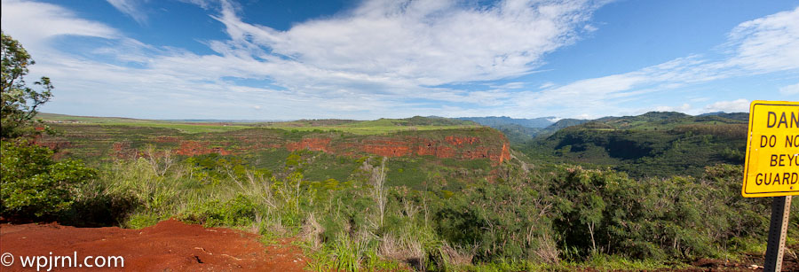
Hawaii’s majestic ‘Grand Canyon of the Pacific’ offers breathtaking vistas of red cliffs, lush valleys, and dramatic geological formations.

Waimea Canyon is one of Kauai’s most iconic natural wonders, a stunning 3,600-foot-deep gorge carved by the Waimea River over millions of years. Often called the ‘Grand Canyon of the Pacific,’ this remarkable landscape showcases vibrant red and orange cliffs layered with green vegetation, creating a striking contrast that changes throughout the day as sunlight shifts across the canyon walls. The canyon stretches approximately 10 miles long and up to 1 mile wide, offering visitors multiple viewpoints and hiking opportunities that reveal the raw beauty of Kauai’s rugged interior.

The geological formations visible at Waimea Canyon tell the story of Kauai’s ancient volcanic past, with exposed lava flows and erosion patterns that create an otherworldly landscape. The combination of tropical climate and dramatic topography results in unique ecosystems, from lush fern-filled valleys to arid ridges. Whether you’re a casual sightseeer or an adventurous hiker, Waimea Canyon provides an unforgettable glimpse into Hawaii’s natural splendor.

Highlights

  • Dramatic red and orange cliff formations rising thousands of feet above the valley floor
  • Multiple scenic overlooks offering panoramic views of the canyon and surrounding landscape
  • Lush green valleys and waterfalls visible from various vantage points along the rim
  • Well-maintained trails ranging from easy walks to challenging hikes for all fitness levels
  • Spectacular sunset and sunrise views with changing light painting the canyon walls in different hues

What to Do

  • Stop at designated lookout points along Waimea Canyon Drive for stunning photo opportunities
  • Hike the Waimea Canyon Trail for a more intimate experience descending into the gorge
  • Explore the Puu Hinahina Lookout for expansive views toward the Na Pali Coast
  • Visit during sunrise or sunset to witness the canyon’s dramatic color transformations
  • Pack a picnic and spend time at scenic viewpoints reflecting on the natural grandeur

Best Time to Visit

April through September offers the most stable weather and clearest views, though the canyon is beautiful year-round. Visit early morning or late afternoon for optimal light and fewer crowds, and avoid rainy days when visibility is limited.

Getting There

From Lihue, take Highway 50 west toward Waimea, then follow Waimea Canyon Drive (Highway 550) which climbs into the canyon. The drive takes approximately 45 minutes to 1 hour from the main towns. Rental cars are recommended for accessing the various overlooks.

Visitor Tips

  • Bring plenty of water and sun protection as there is minimal shade at most viewpoints
  • Wear sturdy hiking boots if planning to hike beyond the main overlooks
  • Check weather conditions before visiting as afternoon clouds often obscure views
  • Arrive early in the day to secure parking and avoid crowds at popular overlooks
  • The road can be narrow and winding; drive carefully and allow extra time if unfamiliar with mountain roads

Nearby

  • Kalalau Lookout near the end of Waimea Canyon Drive offering views of the Na Pali Coast
  • Kokee State Park adjacent to Waimea Canyon with additional hiking trails and accommodations
  • Polihale State Park on the western shore of Kauai featuring an expansive beach
  • Waimea Town with local restaurants and cultural historical sites

Waimea Canyon represents nature’s raw sculptural power, a place where geology becomes art and every viewpoint offers a new perspective on Hawaii’s extraordinary landscape. Whether you spend a few hours exploring the overlooks or dedicate a full day to hiking its trails, the canyon’s majesty will leave an indelible mark on your soul. Plan your visit to this Pacific paradise and experience why generations of travelers have been captivated by this geological masterpiece.

Location Map

Waimea Canyon, Kauai Hawaii Read More »
Mutianyu Section, Great Wall of China, Beijing

Mutianyu Section, Great Wall of China, Beijing
A stunning and less-crowded section of the Great Wall offering breathtaking mountain views and authentic Ming Dynasty architecture.

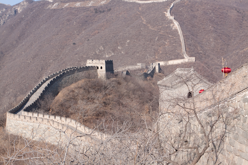
The Mutianyu section of the Great Wall of China stands as one of the most scenic and well-preserved portions of this legendary fortification. Located in the Huairou District north of Beijing, Mutianyu stretches across dramatic mountainous terrain, featuring 22 watchtowers connected by carefully restored stone walls that wind through dense forests and verdant valleys. Unlike the more heavily trafficked Badaling section, Mutianyu offers visitors a more intimate and authentic experience of this UNESCO World Heritage Site, combining natural beauty with historical significance.

Built during the Ming Dynasty (1368-1644), Mutianyu was strategically positioned to protect the capital from northern invasions. The section is renowned for its excellent preservation and the harmonious integration of the wall with its surrounding landscape. Visitors are treated to panoramic vistas of the wall snaking across forested ridges, ancient watchtowers standing sentinel over the valleys, and the seasonal transformations that paint the mountains in different hues throughout the year.

Whether visiting in winter’s serene silence or summer’s lush abundance, Mutianyu delivers an unforgettable journey through centuries of history and across some of northern China’s most compelling natural scenery.

Highlights

  • 22 restored watchtowers with stunning architectural detail and strategic positioning
  • Scenic cable car and toboggan ride options for convenient access to different sections
  • Less crowded than Badaling, offering a more peaceful and authentic experience
  • Dense forests surrounding the wall, changing seasonally from winter white to summer green
  • Excellent preservation showcasing authentic Ming Dynasty construction techniques

What to Do

  • Hike the restored wall sections between watchtowers for panoramic mountain views and photo opportunities
  • Ride the cable car up the mountain for easy access to higher sections of the wall
  • Descend via the thrilling toboggan ride for an adventurous return journey
  • Explore individual watchtowers and their defensive architectural features
  • Pack a picnic and enjoy meals with views of the wall stretching across the landscape

Best Time to Visit

September to October when fall foliage creates stunning golden and red hues across the mountains, or April to May for spring wildflowers and mild temperatures. Winter (as shown in this photo) offers serene, snow-dusted vistas with fewer tourists.

Getting There

From Beijing, take a bus or private car north through Huairou District (approximately 1.5-2 hours). Multiple tour operators offer day trips from central Beijing including transportation. Alternatively, use local buses or hire a taxi from Huairou Town.

Visitor Tips

  • Book tickets online in advance, especially during peak seasons, to avoid long queues
  • Wear sturdy hiking boots with good traction, as stone steps can be steep and slippery
  • Bring sufficient water and snacks, as facilities on the wall are limited
  • Start early to maximize daylight and enjoy the wall in relative solitude
  • Check weather conditions before visiting, as mountain weather changes rapidly

Nearby

  • Jinshanling Great Wall – another well-preserved section with cable car and lakeside views
  • Simatai Great Wall – wild and steep section popular with hikers and photographers
  • Huailai County – scenic rural area with traditional villages and folk culture

Mutianyu represents more than just stone and brick winding through mountains—it embodies centuries of human determination, strategic vision, and architectural mastery. Standing on its watchtowers, gazing across the forested ridges and valleys, you connect with countless generations who walked these same paths. Whether you seek historical insight, outdoor adventure, or simply stunning natural beauty, Mutianyu delivers an experience that captures the grandeur and romance of the Great Wall while remaining accessible and welcoming to travelers of all abilities.

Location Map

Mutianyu Section, Great Wall of China, Beijing Read More »

Scroll to Top