Boeing 767-300 take off at down in New York Kennedy JFK – Lan Airlines LA533 JFK-SCL – New York to Santiago de Chile – Business Class Cabin (Premium Business Lan Chile) . sunset in new york and long beach
[gmap]
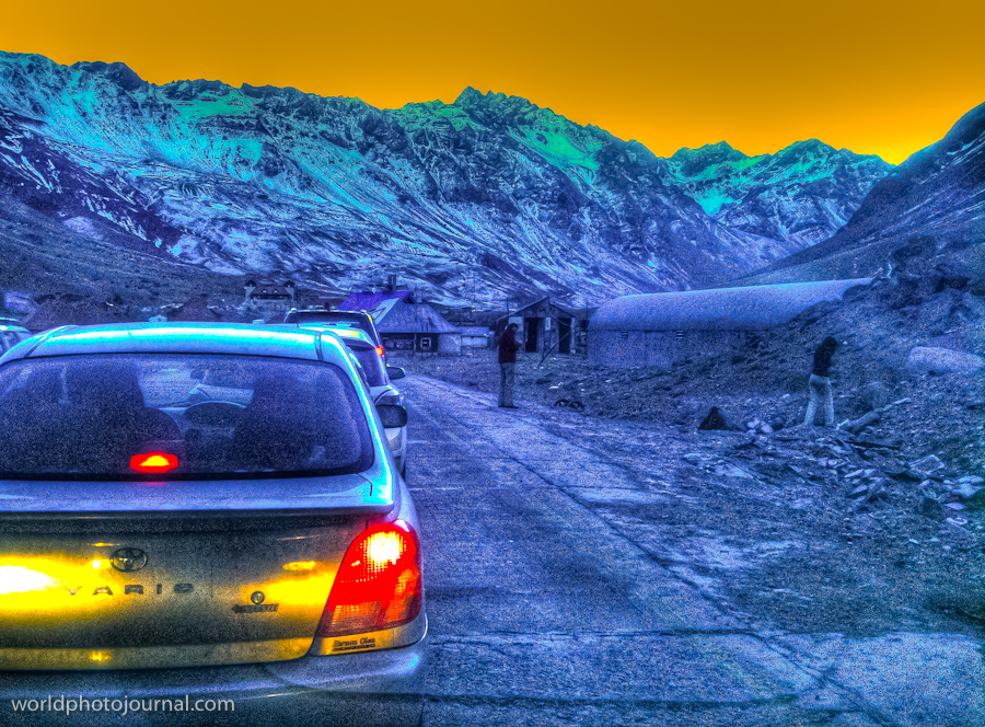
A dramatic high-altitude mountain pass offering stunning Andean vistas and an otherworldly landscape of colorful peaks.
Las Cuevas is a remote mountain pass located in the Andes along the border region between Argentina and Chile. Situated at over 3,000 meters elevation, this stark and beautiful landscape features towering peaks with distinctive turquoise and purple mineral colorations that create an almost surreal visual experience. The pass serves as an important route through the Andes and attracts adventurers, photographers, and travelers seeking authentic mountain wilderness and dramatic natural scenery.
The area is characterized by its barren, rocky terrain and extreme high-altitude environment where vegetation is sparse and the climate is harsh. Despite its remote nature, Las Cuevas has become increasingly popular with travelers exploring the Andean region, drawn by its unique geological formations and the sense of adventure that comes with visiting such a remote location.
The changing light throughout the day transforms the landscape dramatically, from golden sunrise hues to deep blues and purples at dusk, making it a paradise for photographers and nature enthusiasts seeking to capture the raw beauty of the Andes.
Highlights
Dramatic turquoise and purple mineral-colored mountain peaks with striking geological formations
High-altitude Andean pass offering panoramic vistas of untouched wilderness
Remote location providing genuine solitude and connection with nature
What to Do
Photography expeditions capturing the colorful peaks and changing light conditions
Hiking and trekking through the Andean terrain to explore nearby summits
Scenic drives along mountain passes with breathtaking overlooks
Best Time to Visit
December to March (Southern Hemisphere summer) when weather is most stable and passes are accessible; however, Las Cuevas is visitable year-round for experienced travelers
Getting There
Las Cuevas is accessible by vehicle from Mendoza via Route 7 heading towards the Chilean border. The journey takes approximately 3-4 hours from Mendoza city. High-clearance vehicles are recommended due to mountain terrain.
Visitor Tips
Bring layers and windproof clothing as temperatures can drop significantly at high altitude
Carry plenty of water and snacks as services are extremely limited in this remote area
Start early in the day to maximize daylight and safely navigate mountain roads
Check weather conditions and road status before traveling as passes can close seasonally
Allow extra time for acclimatization if coming from lower elevations
Nearby
Aconcagua National Park – home to the highest peak in the Americas
Puente del Inca – historic stone bridge and archaeological site
Mendoza Wine Region – renowned vineyards and wineries
Las Cuevas represents the raw, untamed beauty of the Andes at their most dramatic and colorful. For travelers seeking an authentic high-altitude adventure away from crowds, this remote mountain pass offers an unforgettable experience where nature’s geological artistry is on full display. Whether you’re a photographer, adventurer, or simply someone seeking to stand at the edge of the world, Las Cuevas beckons with its stark beauty and transformative mountain wilderness.
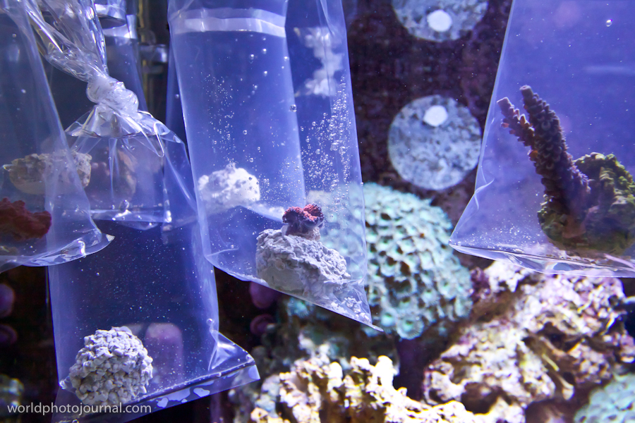
Witness the delicate process of helping corals adapt to new environments in specialized marine laboratory tanks.
This specialized marine research facility showcases the critical work of coral acclimatization—the process of gradually introducing corals to new water conditions before placement in larger reef systems. The laboratory features individual acclimation chambers where corals undergo a carefully controlled transition period. Through clear acrylic containers and precise environmental monitoring, researchers ensure that delicate coral specimens survive and thrive when moved from their source to new habitats. This behind-the-scenes look reveals the scientific dedication required to preserve coral populations and support reef restoration efforts worldwide.
Highlights
Individual acclimation chambers with controlled water conditions and lighting
Real-time observation of coral adaptation processes through clear containers
Advanced monitoring systems maintaining precise salinity, pH, and temperature
Educational displays explaining coral biology and conservation techniques
Active research supporting global reef restoration initiatives
What to Do
Observe corals in various stages of acclimatization and adaptation
Learn about the science of coral husbandry and marine conservation
Watch feeding demonstrations and coral care techniques
Understand the connection between acclimatization and reef restoration success
Discover how aquarium facilities contribute to species preservation
Best Time to Visit
Year-round, as laboratory conditions remain controlled; guided tours often available during regular business hours for maximum learning
Getting There
Located within a marine research center or advanced aquarium facility; check specific venue for public access hours and transportation options
Visitor Tips
Arrive early for less crowded observation times and better photography
Ask staff about the specific corals on display and their origin stories
Be respectful of research operations—quiet observation ensures accurate data collection
Check if guided educational tours are available for deeper insights
Consider visiting conservation-focused facilities that support research efforts
Nearby
Main aquarium exhibits featuring established reef systems
Research library with publications on coral science
Gift shop supporting conservation programs
Educational centers about marine biology
Visiting a coral acclimatization facility provides a unique glimpse into the meticulous science protecting our planet’s coral reefs. These laboratories represent hope for reef restoration and demonstrate humanity’s commitment to preserving one of Earth’s most vital ecosystems. Witnessing these efforts firsthand inspires appreciation for marine conservation and the interdisciplinary work required to sustain ocean health for future generations.
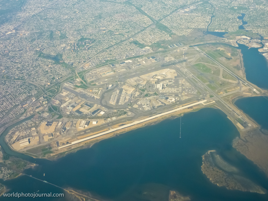
One of America’s busiest international aviation hubs, a marvel of infrastructure connecting the world to New York City.
John F. Kennedy International Airport stands as one of the most iconic and important transportation hubs in the world. Located in Queens, New York, this sprawling complex serves as the primary international gateway to New York City and the northeastern United States. From above, JFK reveals its impressive scale—multiple runways, extensive taxiways, and massive terminal facilities demonstrate the engineering prowess required to handle millions of passengers and cargo shipments annually. The airport has been a symbol of American aviation since its opening in 1948, and it continues to evolve as a modern, world-class facility.
Highlights
Multiple runways designed to handle simultaneous aircraft operations
Extensive terminal infrastructure with nine passenger terminals serving major airlines
Strategic location on Jamaica Bay with careful environmental planning
Advanced ground transportation systems including rail, highways, and parking facilities
State-of-the-art cargo handling and logistics operations
What to Do
Explore the airport’s art installations and architectural features in the terminals
Visit the TWA Flight Center, a historic modernist building designed by Eero Saarinen
Watch aircraft operations from designated viewing areas
Experience world-class dining and shopping in the modern terminals
Use the AirTrain rail system connecting the airport to Manhattan and outer boroughs
Best Time to Visit
Any season is suitable for visiting JFK as a transit point or to observe airport operations. Summer months see peak travel activity, while winter offers clearer skies for aerial photography.
Getting There
JFK is accessible via the AirTrain rail system, which connects to the Jamaica and Howard Beach subway stations. The airport is also reachable by car via the Van Wyck Expressway, Jamaica Expressway, and other major roads.
Visitor Tips
Arrive extra early if you’re flying—busy airport with significant passenger volume
Use the AirTrain for convenient ground transportation to avoid traffic delays
Explore terminal amenities during layovers; each terminal has distinct dining and shopping
Check current airport updates and security procedures before visiting
Consider timing your visit to avoid peak travel periods for shorter wait times
Nearby
Jamaica Bay Wildlife Refuge for nature observation
Aqueduct Racetrack for sports entertainment
Queens neighborhoods with diverse dining and cultural attractions
Flushing Meadows-Corona Park with museums and recreational facilities
JFK Airport is more than just a transportation hub—it’s a testament to human ingenuity and a gateway to endless possibilities. Whether you’re passing through or interested in witnessing one of the world’s busiest airports in action, JFK offers a fascinating glimpse into modern aviation and the vital role airports play in connecting our global community. From the moment you see its impressive infrastructure from above, you’ll understand why it remains one of the most important aviation facilities in the world.
A striking aviation facility showcasing the industrial beauty and scale of Canada’s busiest airport.
Pearson International Airport in Toronto is one of North America’s major aviation hubs, serving millions of passengers annually. This photograph captures the impressive Skyservice hangar facility, a testament to modern airport infrastructure and aviation maintenance operations. The dramatic sky and verdant surrounding landscape frame this architectural landmark, highlighting the contrast between human engineering and natural beauty. The hangar’s substantial size and functional design reflect the critical role Pearson plays in connecting Toronto and the Greater Toronto Area to the world.
Highlights
Massive Skyservice maintenance hangar with distinctive industrial architecture
Parked aircraft visible on the tarmac representing active aviation operations
Located at Canada’s largest and busiest airport
Strategic location serving the Greater Toronto Area and beyond
Modern infrastructure supporting international air travel
What to Do
Take a tour of airport facilities if available through official channels
Visit the airport’s observation areas to watch aircraft operations
Explore the adjacent hotels and dining facilities within the terminal
Photograph the impressive hangars and aircraft from designated areas
Learn about aviation history at nearby museums
Best Time to Visit
Year-round, though spring and summer offer the clearest skies for photography and observation. The dramatic cloud formations visible in this image are typical of changing seasons.
Getting There
Pearson International Airport is located approximately 27 kilometers northwest of downtown Toronto, accessible via the Gardiner Expressway, Queen Elizabeth Way, or public transit including GO Transit and the UP Express train.
Visitor Tips
Check airport website for tour availability and security procedures
Arrive early if planning to photograph aircraft operations
Weather can change rapidly; bring appropriate clothing
Respect restricted areas and follow all airport security guidelines
Best photography opportunities vary with time of day and seasonal light
Nearby
Toronto City Centre Airport (Billy Bishop)
Royal Ontario Museum in downtown Toronto
Niagara Falls (45 minutes away)
Toronto Pearson Hotels and lounges
Pearson International Airport stands as a gateway to discovery and adventure, connecting travelers from around the world to the vibrant culture and opportunities of Toronto and Canada. Whether you’re fascinated by aviation, industrial architecture, or simply appreciate the scale of modern infrastructure, Pearson offers a compelling glimpse into the vital networks that keep our world connected.