waterfront

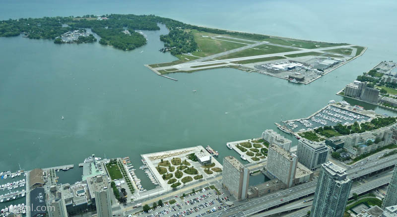
Toronto Island Airport Aerial View, Toronto Canada
Toronto Island Airport Aerial View, Toronto Canada
A modern urban airport nestled on an island in Lake Ontario, offering stunning views of Toronto’s skyline and waterfront.

Toronto Island Airport (YTZ) is a unique and picturesque airport located on the Toronto Islands, just minutes from downtown Toronto. This intimate urban airport serves as a gateway to Canada’s largest city while maintaining a distinctive island setting surrounded by Lake Ontario’s turquoise waters. The aerial view showcases the remarkable blend of urban infrastructure, green spaces, and natural waterfront beauty that makes this airport a memorable departure and arrival point for travelers.

The airport’s strategic location on the islands provides visitors with breathtaking panoramic views of downtown Toronto, the CN Tower, and the surrounding Lake Ontario landscape. Its compact, well-designed runway and modern facilities make it an efficient alternative to larger regional airports, while the island setting preserves a sense of tranquility and natural beauty.

Highlights

  • Stunning aerial views of downtown Toronto and Lake Ontario during flights
  • Modern terminal facilities with excellent amenities and dining options
  • Direct waterfront access with beautiful pedestrian pathways and parks
  • Close proximity to downtown Toronto (just 2 minutes by ferry)
  • Unique island location offering scenic beauty and recreational opportunities

What to Do

  • Take scenic flights departing from the airport to view Toronto’s skyline from above
  • Explore the Toronto Islands parks and green spaces surrounding the airport
  • Visit nearby attractions on the islands including beaches and nature trails
  • Enjoy waterfront dining and shopping at the airport’s terminal
  • Capture stunning photographs of the airport, waterfront, and downtown skyline

Best Time to Visit

Late spring through early fall (May-September) offers the best weather for clear aerial views and comfortable exploration of the surrounding islands. Summer provides ideal conditions for enjoying the waterfront parks and outdoor activities.

Getting There

Toronto Island Airport is accessible by ferry from downtown Toronto (2-minute journey), by water taxi, or by private boat. The airport is served by regional airlines offering flights to major Canadian and US destinations.

Visitor Tips

  • Arrive early to enjoy the waterfront views and facilities before your flight
  • Take the scenic ferry ride to fully appreciate the island’s natural beauty
  • Pack a camera to capture the impressive aerial views of Toronto during takeoff and landing
  • Check weather conditions for optimal visibility of the downtown skyline
  • Explore the islands’ parks and trails after your flight for additional scenic experiences

Nearby

  • Toronto Islands Parks and Beaches
  • CN Tower, downtown Toronto
  • Distillery District historic neighborhood
  • St. Lawrence Market
  • Harbourfront Centre and waterfront

Toronto Island Airport represents a perfect intersection of modern aviation and natural beauty, offering travelers an unforgettable experience from the moment they arrive. Whether departing or arriving, the stunning aerial views of downtown Toronto and Lake Ontario create lasting memories. For visitors seeking a unique urban airport experience combined with access to pristine waterfront landscapes, Toronto Island Airport is an essential destination that captures the essence of Canada’s vibrant largest city.

Location Map

Toronto Island Airport Aerial View, Toronto Canada Read More »
Toronto Lakeshore and QEW, Toronto Canada

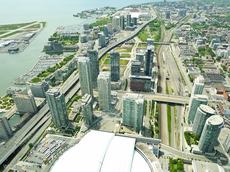
Toronto Lakeshore and QEW, Toronto Canada
An aerial perspective of Toronto’s dynamic waterfront where modern urban development meets critical transportation infrastructure.

This stunning aerial view captures Toronto’s lakeshore district and the Queen Elizabeth Way (QEW) interchange, showcasing the city’s remarkable urban landscape and strategic position on Lake Ontario. The image reveals how Toronto has evolved as a major metropolitan hub, with gleaming residential and commercial towers rising alongside complex highway systems that connect the Greater Toronto Area. The contrast between the serene waterfront, bustling city center, and intricate transportation networks illustrates Toronto’s role as Canada’s largest city and a vital economic engine.

Highlights

  • Aerial view of Toronto’s downtown waterfront with Lake Ontario and harbor facilities
  • The Queen Elizabeth Way (QEW) major highway interchange connecting Toronto to Niagara Falls and Southern Ontario
  • Modern high-rise residential and commercial developments in the downtown core
  • Green spaces and parks integrated throughout the urban landscape
  • Toronto’s complex transportation infrastructure including elevated highways and rail corridors

What to Do

  • Explore the waterfront attractions including museums, galleries, and entertainment venues along Lake Ontario
  • Visit the Ripley’s Aquarium and CN Tower for panoramic city views
  • Walk along the Toronto Waterfront Trail for cycling, jogging, or leisurely strolls
  • Discover downtown Toronto’s diverse neighborhoods including St. Lawrence, Distillery District, and Entertainment District
  • Experience the city’s cultural institutions, restaurants, and shopping districts

Best Time to Visit

Late spring through early fall (May-September) offers the best weather for waterfront activities, though winter provides a different urban charm with potential lakefront snow scenes.

Getting There

Toronto is accessible by air via Pearson International Airport, by train through Union Station, and by car via the QEW and other major highways. The city has extensive public transit via the Toronto Transit Commission (TTC).

Visitor Tips

  • The QEW is a major commercial route; expect congestion during rush hours if driving
  • Use the TTC subway, streetcar, or bus system to navigate downtown without a car
  • The Waterfront Trail offers excellent views and is best explored on foot or by bicycle
  • Check weather conditions, especially in winter, before planning waterfront visits
  • Parking downtown can be expensive; use paid lots or public transit

Nearby

  • CN Tower and Entertainment District
  • St. Lawrence Market and Distillery District
  • Harbourfront Centre and Toronto Islands
  • Casa Loma historic mansion
  • Ripley’s Aquarium and Marine Museum

Toronto’s lakeshore and transportation corridors represent the lifeblood of Canada’s largest city, where modern architecture meets natural beauty and urban energy flows seamlessly across the landscape. Whether you’re drawn to the waterfront’s cultural attractions, the vibrant downtown core, or simply want to experience one of North America’s most dynamic cities, Toronto offers an unforgettable blend of urban sophistication and lakeside charm.

Location Map

Toronto Lakeshore and QEW, Toronto Canada Read More »
Westhaven Marina, Auckland New Zealand

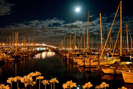
Westhaven Marina, Auckland New Zealand
A picturesque waterfront marina in Auckland where sailboats and moonlight create an enchanting nocturnal escape.

Westhaven Marina is one of Auckland’s most scenic and vibrant maritime destinations, nestled in the heart of the city’s waterfront. This bustling marina serves as a haven for sailing enthusiasts and casual visitors alike, offering stunning views of moored yachts and sailboats set against the glittering cityscape. The marina’s charming character is elevated during twilight hours when the moon rises over the water, casting a magical glow across the boats and creating an atmosphere of serene beauty and maritime romance.

The marina is perfectly positioned to showcase Auckland’s dual nature—a modern city that deeply embraces its maritime heritage. With dozens of sailboats anchored in the protected waters, lined wooden wharfs, and golden-lit pathways, Westhaven provides both a functional hub for the sailing community and a breathtaking destination for those seeking peaceful waterfront ambiance.

Whether you’re a sailing enthusiast, photographer, or simply someone seeking a tranquil escape from urban bustle, Westhaven Marina offers year-round appeal and serves as a gateway to understanding Auckland’s strong connection to the sea.

Highlights

  • Hundreds of moored sailboats creating a forest of masts against the sky
  • Stunning moonlit views and evening illumination reflecting off the water
  • Direct access to Auckland’s waterfront and harbourside dining
  • Perfect vantage point for photography, especially during golden hour and night
  • Close proximity to Auckland’s CBD and other major attractions

What to Do

  • Stroll along the marina walkways and admire the yachts and sailboats up close
  • Capture photographs during sunset and moonrise for magical lighting
  • Visit waterfront restaurants and cafes nearby for dining with a view
  • Book a sailing charter or yacht experience departing from the marina
  • Relax on the waterfront benches and watch the maritime activity
  • Explore the surrounding Viaduct and waterfront precinct

Best Time to Visit

Year-round, though spring (September-November) and autumn (March-May) offer pleasant weather. Evening visits during full moon phases provide particularly dramatic lighting and photographic opportunities.

Getting There

Westhaven Marina is located in central Auckland, approximately 2 km north of the CBD. It’s easily accessible by car (ample parking available), public transport (bus routes serve the area), or on foot from downtown Auckland. Taxi and ride-sharing services are readily available.

Visitor Tips

  • Visit during evening or night hours for the most stunning atmospheric lighting and fewer crowds
  • Bring a camera or smartphone for photography—the moonlit marina is exceptionally photogenic
  • Check moon phases ahead of time to plan visits during full moon for optimal lighting
  • Wear layers as waterfront evenings can be cool, even in warmer months
  • Arrive early during popular times to secure good viewpoints and parking

Nearby

  • Auckland Viaduct and waterfront precinct with restaurants and shops
  • New Zealand Maritime Museum
  • Auckland CBD and Britomart shopping district
  • Parks and gardens surrounding the harbor area

Westhaven Marina encapsulates the magic of Auckland’s maritime spirit, offering visitors a serene yet vibrant waterfront experience. Whether illuminated by moonlight or the warm glow of evening lights, this iconic marina invites you to step into a world where elegant sailboats, starry skies, and urban sophistication merge into an unforgettable Kiwi experience. Come discover why this beloved local gem has captivated sailors and travelers for generations.

Location Map

Westhaven Marina, Auckland New Zealand Read More »
Bayside Marketplace, Miami Florida

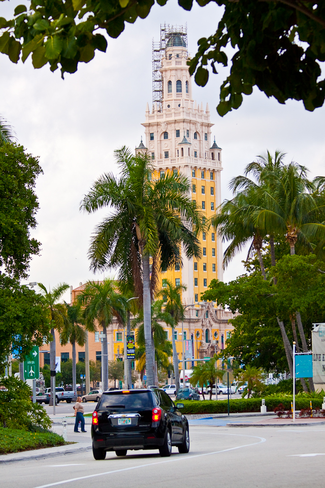
Bayside Marketplace, Miami Florida
A vibrant waterfront destination in downtown Miami offering shopping, dining, and stunning views of Biscayne Bay.

Bayside Marketplace is Miami’s premier waterfront shopping and entertainment complex located in the heart of downtown Miami. This iconic destination perfectly blends urban sophistication with tropical charm, featuring the distinctive Freedom Tower—a historic 1925 landmark with its iconic yellow and cream-colored architecture—as a backdrop to the bustling marketplace. The open-air plaza offers a dynamic atmosphere where locals and tourists converge to experience world-class shopping, diverse cuisine, and the natural beauty of Biscayne Bay.

Highlights

  • Freedom Tower landmark with its distinctive Moorish Revival architecture and ongoing restoration
  • Waterfront promenade with scenic views of Biscayne Bay and sailboats
  • Diverse dining options ranging from casual to upscale restaurants and cafes
  • Open-air marketplace with local vendors, boutiques, and retail shops
  • Live entertainment and cultural events throughout the year
  • Lush tropical landscaping with palm trees and green spaces

What to Do

  • Stroll the waterfront promenade and enjoy bay views while shopping
  • Dine at waterfront restaurants offering fresh seafood and international cuisine
  • Visit the Freedom Tower to learn about Miami’s history
  • Browse local boutiques and vendor stalls for unique souvenirs
  • Catch live music performances and cultural events
  • Relax in the landscaped plazas with tropical palm surroundings

Best Time to Visit

November through April, when Miami’s weather is pleasant with cooler temperatures and lower humidity, perfect for exploring the outdoor marketplace

Getting There

Bayside Marketplace is located downtown Miami, easily accessible by car (paid parking available), public transportation via Metromover or bus, or taxi/rideshare services. The location is walkable from nearby hotels and attractions

Visitor Tips

  • Visit early morning or late afternoon to avoid peak crowds and heat
  • Bring sunscreen and wear comfortable walking shoes for exploring
  • Check the events calendar for live performances and special activities
  • Allow 2-3 hours to fully explore shopping, dining, and waterfront areas
  • Public restrooms and water fountains are available throughout the marketplace

Nearby

  • American Airlines Arena (sports and concerts)
  • Miami-Dade Cultural Center and museums
  • Brickell financial district
  • South Pointe Park

Bayside Marketplace captures the essence of Miami—a perfect fusion of historic architecture, tropical beauty, and contemporary urban energy. Whether you’re shopping for unique finds, enjoying fresh seafood with bay views, or simply soaking in the vibrant atmosphere, Bayside offers an unforgettable waterfront experience that showcases why Miami is such a dynamic and beloved destination.

Location Map

Bayside Marketplace, Miami Florida Read More »

Scroll to Top