aviation

Above the Clouds – Aerial View from Flight AA86 ORD-LHR

Above the Clouds - Aerial View from Flight AA86 ORD-LHR
Experience the serene beauty of soaring above a blanket of white clouds on a transatlantic journey.

This breathtaking aerial photograph captures the magic of flight at cruising altitude, taken aboard American Airlines Flight AA86 from Chicago O’Hare (ORD) to London Heathrow (LHR). The image showcases the stunning vista that passengers encounter when flying above weather systems—a sea of billowing white clouds bathed in brilliant sunlight against a deep blue sky. This perspective reminds travelers of the wonder of modern aviation and the privilege of witnessing Earth’s atmospheric beauty from above.

Transatlantic flights offer some of the most spectacular views available to commercial airline passengers. The journey from Chicago to London spans approximately 3,600 miles across the Atlantic Ocean, often taking passengers above various weather patterns and cloud formations that create natural artwork in the sky.

Highlights

  • Stunning cloud formations creating a sea-like appearance from cruising altitude
  • Clear blue sky providing contrast to the white cloud layer
  • Typical view experienced on long-haul transatlantic flights
  • Perfect conditions for photography and window-seat observations

What to Do

  • Book a window seat to capture similar views during your transatlantic flight
  • Watch for changing cloud formations throughout different flight phases
  • Photograph the sunset or sunrise from above the clouds
  • Document the transition between different weather systems during the flight

Best Time to Visit

Clear weather days offer the best cloud photography opportunities, typically during stable high-pressure systems. Early morning or late afternoon flights often provide optimal lighting conditions.

Getting There

American Airlines Flight AA86 operates daily from Chicago O’Hare International Airport (ORD) to London Heathrow Airport (LHR), a direct transatlantic service of approximately 7-8 hours.

Visitor Tips

  • Request a window seat during booking for optimal cloud viewing
  • Bring a good camera or smartphone to capture these fleeting moments
  • Travel during seasons with clear weather patterns for better visibility
  • Consider the sun position when choosing your flight time for best lighting

Nearby

  • Chicago O’Hare International Airport observation areas
  • London Heathrow Airport visitor experiences
  • Various cloud-watching vantage points along the transatlantic route

The view above the clouds represents one of aviation’s greatest gifts to travelers—a perspective that reminds us of our planet’s beauty and the incredible journeys we can undertake. Whether you’re a seasoned flyer or embarking on your first transatlantic adventure, the sight of this magnificent cloud bed from flight AA86 will leave you with unforgettable memories and a renewed appreciation for the wonder of flight.

Location Map

Above the Clouds – Aerial View from Flight AA86 ORD-LHR Read More »

Video HD: Crossing The Andes at sunset – LA461 SCL-AEP – Airbus 318 – Lan Airlines – Premium Economy

Crossing The Andes at sunset in LA461 from Santiago de Chile to Buenos Aires Aeroparque jorge Newbery Airport (SCL-AEP) in an Airbus 318 from Lan Airlines. Amazing aerial views from the Andes. Premium Economy Seat.

Location Map
Video HD: Crossing The Andes at sunset – LA461 SCL-AEP – Airbus 318 – Lan Airlines – Premium Economy Read More »

Video HD: Boeing 777 take off at night in Buenos Aires, Argentina – American Airlines AA956 EZE-JFK – First Class

http://wpjrnl.com/ Amazing aerial views of Buenos Aires, Argentina at night – Boeing 777 take off at night in Buenos Aires – American Airlines AA956 EZE-JFK – Buenos Aires to New York – From First Class Seat

Location Map

Video HD: Boeing 777 take off at night in Buenos Aires, Argentina – American Airlines AA956 EZE-JFK – First Class Read More »

Boeing 767-300 take off in New York Kennedy JFK – Lan Airlines LA533 JFK-SCL – Business Class

Boeing 767-300 take off at down in New York Kennedy JFK – Lan Airlines LA533 JFK-SCL – New York to Santiago de Chile – Business Class Cabin (Premium Business Lan Chile) . sunset in new york and long beach [gmap]

Location Map

Boeing 767-300 take off in New York Kennedy JFK – Lan Airlines LA533 JFK-SCL – Business Class Read More »

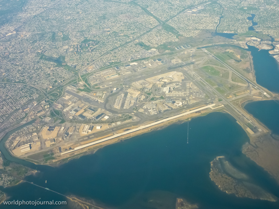
JFK Airport Aerial View, New York USA

JFK Airport Aerial View, New York USA
One of America’s busiest international aviation hubs, a marvel of infrastructure connecting the world to New York City.

John F. Kennedy International Airport stands as one of the most iconic and important transportation hubs in the world. Located in Queens, New York, this sprawling complex serves as the primary international gateway to New York City and the northeastern United States. From above, JFK reveals its impressive scale—multiple runways, extensive taxiways, and massive terminal facilities demonstrate the engineering prowess required to handle millions of passengers and cargo shipments annually. The airport has been a symbol of American aviation since its opening in 1948, and it continues to evolve as a modern, world-class facility.

Highlights

  • Multiple runways designed to handle simultaneous aircraft operations
  • Extensive terminal infrastructure with nine passenger terminals serving major airlines
  • Strategic location on Jamaica Bay with careful environmental planning
  • Advanced ground transportation systems including rail, highways, and parking facilities
  • State-of-the-art cargo handling and logistics operations

What to Do

  • Explore the airport’s art installations and architectural features in the terminals
  • Visit the TWA Flight Center, a historic modernist building designed by Eero Saarinen
  • Watch aircraft operations from designated viewing areas
  • Experience world-class dining and shopping in the modern terminals
  • Use the AirTrain rail system connecting the airport to Manhattan and outer boroughs

Best Time to Visit

Any season is suitable for visiting JFK as a transit point or to observe airport operations. Summer months see peak travel activity, while winter offers clearer skies for aerial photography.

Getting There

JFK is accessible via the AirTrain rail system, which connects to the Jamaica and Howard Beach subway stations. The airport is also reachable by car via the Van Wyck Expressway, Jamaica Expressway, and other major roads.

Visitor Tips

  • Arrive extra early if you’re flying—busy airport with significant passenger volume
  • Use the AirTrain for convenient ground transportation to avoid traffic delays
  • Explore terminal amenities during layovers; each terminal has distinct dining and shopping
  • Check current airport updates and security procedures before visiting
  • Consider timing your visit to avoid peak travel periods for shorter wait times

Nearby

  • Jamaica Bay Wildlife Refuge for nature observation
  • Aqueduct Racetrack for sports entertainment
  • Queens neighborhoods with diverse dining and cultural attractions
  • Flushing Meadows-Corona Park with museums and recreational facilities

JFK Airport is more than just a transportation hub—it’s a testament to human ingenuity and a gateway to endless possibilities. Whether you’re passing through or interested in witnessing one of the world’s busiest airports in action, JFK offers a fascinating glimpse into modern aviation and the vital role airports play in connecting our global community. From the moment you see its impressive infrastructure from above, you’ll understand why it remains one of the most important aviation facilities in the world.

Location Map

JFK Airport Aerial View, New York USA Read More »

Pearson Airport Skyservice Hangar, Toronto Canada

Pearson Airport Skyservice Hangar, Toronto Canada
A striking aviation facility showcasing the industrial beauty and scale of Canada’s busiest airport.

Pearson International Airport in Toronto is one of North America’s major aviation hubs, serving millions of passengers annually. This photograph captures the impressive Skyservice hangar facility, a testament to modern airport infrastructure and aviation maintenance operations. The dramatic sky and verdant surrounding landscape frame this architectural landmark, highlighting the contrast between human engineering and natural beauty. The hangar’s substantial size and functional design reflect the critical role Pearson plays in connecting Toronto and the Greater Toronto Area to the world.

Highlights

  • Massive Skyservice maintenance hangar with distinctive industrial architecture
  • Parked aircraft visible on the tarmac representing active aviation operations
  • Located at Canada’s largest and busiest airport
  • Strategic location serving the Greater Toronto Area and beyond
  • Modern infrastructure supporting international air travel

What to Do

  • Take a tour of airport facilities if available through official channels
  • Visit the airport’s observation areas to watch aircraft operations
  • Explore the adjacent hotels and dining facilities within the terminal
  • Photograph the impressive hangars and aircraft from designated areas
  • Learn about aviation history at nearby museums

Best Time to Visit

Year-round, though spring and summer offer the clearest skies for photography and observation. The dramatic cloud formations visible in this image are typical of changing seasons.

Getting There

Pearson International Airport is located approximately 27 kilometers northwest of downtown Toronto, accessible via the Gardiner Expressway, Queen Elizabeth Way, or public transit including GO Transit and the UP Express train.

Visitor Tips

  • Check airport website for tour availability and security procedures
  • Arrive early if planning to photograph aircraft operations
  • Weather can change rapidly; bring appropriate clothing
  • Respect restricted areas and follow all airport security guidelines
  • Best photography opportunities vary with time of day and seasonal light

Nearby

  • Toronto City Centre Airport (Billy Bishop)
  • Royal Ontario Museum in downtown Toronto
  • Niagara Falls (45 minutes away)
  • Toronto Pearson Hotels and lounges

Pearson International Airport stands as a gateway to discovery and adventure, connecting travelers from around the world to the vibrant culture and opportunities of Toronto and Canada. Whether you’re fascinated by aviation, industrial architecture, or simply appreciate the scale of modern infrastructure, Pearson offers a compelling glimpse into the vital networks that keep our world connected.

Location Map

Pearson Airport Skyservice Hangar, Toronto Canada Read More »

Scroll to Top