
drive to the docks (port of toronto)
drive from east GTA to the docks and downtown Toronto.
Location Map
drive to the docks (port of toronto) Read More »
travel photos
drive to the docks (port of toronto) Read More »
Discover why Groupon’s Super Bowl ad promoting travel to Tibet sparked massive backlash and became one of the most controversial travel advertisements in sports history.
Super Bowl advertisements are known for pushing boundaries, but Groupon’s Tibet travel deal commercial crossed a line that left viewers and activists outraged. This video breaks down the controversial ad that promised budget-friendly Tibetan getaways while making light of serious cultural and political sensitivities. The advertisement became a watershed moment in how travel brands communicate about exotic destinations, raising important questions about responsible tourism marketing, cultural respect, and the ethical obligations of major corporations when promoting travel to culturally significant regions.
This video serves as a crucial case study in travel marketing ethics and brand responsibility. Whether you’re interested in understanding the intersection of commerce and culture, learning about Tibet’s significance, or simply exploring one of the most talked-about Super Bowl ads ever made, this analysis offers valuable insights into why sensitivity matters in the travel industry.

Toronto Pearson International Airport (YYZ) is Canada’s largest and busiest airport, serving as a critical gateway for millions of travelers each year. Gate B16 exemplifies the modern infrastructure and operational efficiency of this world-class facility. The airport’s strategic location in the Greater Toronto Area makes it a vital connector for flights across North America and beyond.
Spring through fall for pleasant weather and minimal flight disruptions; winter can bring weather-related delays
Toronto Pearson is accessible via the UP Express train (24 minutes to downtown), taxis, ride-sharing services, and rental cars from the airport
Toronto Pearson International Airport remains one of North America’s most important aviation hubs, connecting travelers from around the world. Whether you’re departing from Gate B16 or simply observing the fascinating world of international air travel, YYZ represents the gateway to exploring Canada’s vibrant cities and natural wonders.
Toronto Pearson International Airport Gate B16, Toronto Canada Read More »
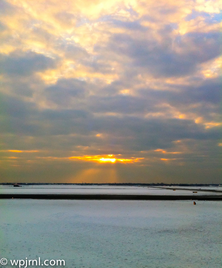
John F. Kennedy International Airport, located in Queens, New York, is one of the world’s busiest airports, but it also offers unexpected moments of natural beauty. After winter snow storms clear the skies, dawn breaks over the airport’s unique landscape of salt marshes, water basins, and tidal areas, creating breathtaking photographic opportunities. The interplay of light, water, and cloud formations during sunrise transforms this industrial setting into a place of remarkable tranquility.
The Jamaica Bay wetlands surrounding JFK provide a striking contrast to the airport’s runways and terminals, offering visitors and photographers a glimpse of nature thriving alongside modern infrastructure. Early morning light casts golden rays across still water and pristine snow-covered landscapes, making the post-storm sunrise particularly magical.
Whether you’re catching an early flight, working at the airport, or simply seeking a unique vantage point for sunrise photography, JFK’s natural surroundings reveal an often-overlooked dimension of this iconic New York location.
Winter mornings after snow storms, when clear skies and fresh snow create optimal sunrise photography conditions with dramatic lighting and pristine landscapes.
JFK Airport is accessible via the AirTrain Jamaica or AirTrain Howard Beach, connecting to the subway and rail systems. Drive access is available via the Van Wyck Expressway. Perimeter roads offer viewing points for sunrise photography.
The sunrise at JFK Airport after a snow storm reveals the hidden natural splendor within one of America’s busiest aviation hubs. This unexpected moment of serenity—where golden light dances across pristine snow and calm waters—reminds us that beauty exists in the most unlikely places. Whether you’re a photographer seeking that perfect shot or a traveler with time before your flight, take a moment to witness the magical transformation of Jamaica Bay at dawn.
JFK Airport Sunrise, Queens New York Read More »
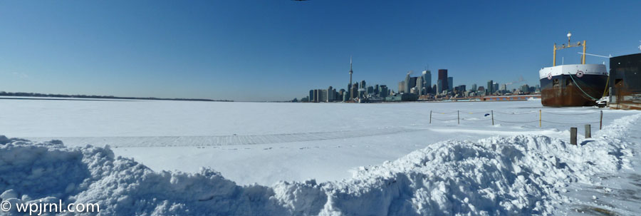
Toronto transforms into a breathtaking winter destination when Lake Ontario freezes over, creating one of the most picturesque natural backdrops for the city’s iconic skyline. This striking vista captures the essence of Canadian winters—pristine snow blankets the frozen lake while the CN Tower and downtown skyscrapers pierce the crystal-clear blue sky. The contrast between the industrial harbor infrastructure and the peaceful frozen expanse creates a uniquely compelling landscape that showcases Toronto at its most photogenic.
The waterfront during winter offers visitors and photographers an opportunity to witness the city from an entirely different perspective. The frozen lake becomes an accessible landscape, while snow-covered shores and docked vessels add layers of visual interest to the scene. This is a place where urban development meets natural beauty, where modern architecture stands in dialogue with the raw power of Canadian winters.
December through February, when Lake Ontario is fully frozen and winter conditions create the most dramatic snow-covered landscapes. Clear winter days offer the best photography and visibility of the skyline.
Take the Toronto Transit Commission (TTC) streetcar to the Harbourfront, or drive to various waterfront parking areas. The Distillery District and St. Lawrence Market are nearby transit-accessible attractions.
Toronto’s winter waterfront is a testament to the raw beauty of Canadian seasons, where urban sophistication meets natural grandeur. Whether you’re a photographer seeking the perfect skyline shot, a traveler exploring Canada’s largest city, or simply someone who appreciates the stark elegance of frozen landscapes, this winter scene offers an unforgettable experience. Bundle up, grab your camera, and discover why Toronto in winter captivates the hearts of all who witness its frozen majesty.
Toronto Waterfront Winter Landscape, Ontario Canada Read More »
driving around downtown toronto (Video HD) Read More »