travel

travel photos

Venice Carnival Lights, Christmas Market — Venice, Italy

Venice Carnival Lights, Christmas Market — Venice, Italy
A magical winter wonderland where twinkling blue lights dance above historic arcades and festive market stalls in Venice’s enchanting squares.

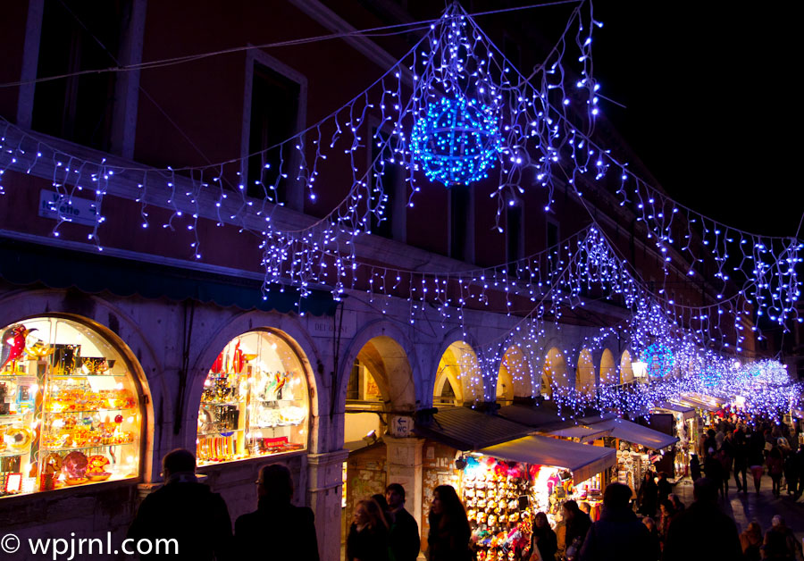
Venice transforms into a shimmering fairytale during the holiday season, with the Carnival Lights creating an unforgettable spectacle against the city’s medieval architecture. This iconic market combines Venice’s centuries-old carnival tradition with festive seasonal charm, drawing visitors from around the world to experience cascading LED installations draped across historic buildings and arches. The blue and purple lights create an ethereal atmosphere that perfectly complements the Venetian Gothic architecture, while artisan vendors below offer handcrafted gifts, ornaments, and local delicacies. The interplay of ancient stone colonnades and modern light displays creates a truly unique blend of old-world beauty and contemporary magic.

Highlights

  • Stunning cascading blue and white LED light installations suspended across historic arcades and buildings
  • Charming market stalls selling handmade Venetian crafts, ornaments, and holiday gifts
  • Illuminated arches and architectural details that frame the festive marketplace
  • Traditional Venetian carnival spirit combined with modern holiday celebrations
  • Perfect photography opportunities amid the glowing lights and historic stone architecture

What to Do

  • Stroll through the market stalls and browse artisan ornaments and Venetian crafts
  • Capture stunning photos of the illuminated arches and light displays
  • Sample local Venetian holiday treats and seasonal delicacies
  • Experience the unique blend of carnival tradition and winter festivity
  • Explore nearby historic squares and discover hidden gems in Venice’s layout

Best Time to Visit

Late November through early January, when the light installations are in full display and the holiday market is operational. December offers the most festive atmosphere with the most visitors.

Getting There

Arrive in Venice via train to Santa Lucia Station or by water taxi from Marco Polo Airport. Navigate Venice’s iconic canals by vaporetto (water bus) or on foot to reach the market squares.

Visitor Tips

  • Arrive early evening to see the lights illuminate as dusk falls—the effect is most magical after dark
  • Wear warm clothing; Venice can be cold and damp during winter months
  • Bring a good camera or smartphone for photography; the blue lights are incredibly photogenic
  • Visit on weekdays if possible to avoid peak crowds
  • Bring comfortable walking shoes; exploring Venice requires extensive walking

Nearby

  • St. Mark’s Basilica and Square
  • Doge’s Palace
  • Bridge of Sighs
  • Grand Canal
  • Rialto Bridge

Venice’s Carnival Lights represent the perfect marriage of ancient Venetian tradition and contemporary festive magic. Walking beneath these shimmering blue cascades while surrounded by centuries-old architecture creates an otherworldly experience that captures the romance and mystery Venice is legendary for. Whether you’re seeking holiday magic, unique souvenirs, or simply an unforgettable evening in one of the world’s most enchanting cities, this seasonal spectacular is an absolute must-see.

Location Map

Venice Carnival Lights, Christmas Market — Venice, Italy Read More »

Il Bacco Felice Restaurant, Venice Italy

Il Bacco Felice Restaurant, Venice Italy
A charming Venetian osteria where locals gather for authentic Italian cuisine in a warm, convivial atmosphere.

Il Bacco Felice is a beloved traditional restaurant nestled in the heart of Venice, Italy. This intimate venue captures the essence of authentic Venetian dining with its rustic charm, exposed wooden beams, and industrial-chic décor that blends old-world character with contemporary warmth. The restaurant draws a diverse crowd of locals and visitors who appreciate genuine Italian food and an unpretentious, lively dining experience. With its chalkboard menus, pendant lighting, and ochre-colored walls adorned with vintage photographs, Il Bacco Felice offers a glimpse into the real Venice beyond the tourist-heavy squares.

Highlights

  • Authentic Venetian cuisine prepared with seasonal, local ingredients
  • Cozy, bustling atmosphere perfect for experiencing local dining culture
  • Rustic interior with exposed wooden beams and industrial touches
  • Chalkboard menus featuring daily specials and fresh offerings
  • Friendly, knowledgeable staff who embody Venetian hospitality

What to Do

  • Enjoy traditional pasta dishes and seafood specialties that showcase regional flavors
  • Sip Italian wines selected to complement authentic Venetian dishes
  • Experience the convivial energy of locals dining and socializing
  • Browse vintage photographs and artworks adorning the restaurant walls
  • Arrive early or make reservations to secure seating in this popular spot

Best Time to Visit

October through November or February through March, when Venice experiences fewer crowds and pleasant weather ideal for exploring the city before or after your meal.

Getting There

Located in Venice’s interior, accessible by foot or vaporetto (water bus). Nearest vaporetto stops depend on specific location within Venice—consult local maps or ask hotel staff for directions.

Visitor Tips

  • Make a reservation in advance, especially during peak tourist season, as this popular spot fills quickly
  • Come hungry—portions are generous and the food is meant to be savored
  • Ask staff for recommendations; they know the day’s specials and can suggest wine pairings
  • Bring cash; some traditional restaurants in Venice may not accept all card types

Nearby

  • Basilica di San Marco
  • Grand Canal
  • Rialto Bridge
  • Doge’s Palace
  • Local Venetian markets and galleries

Il Bacco Felice embodies the soul of Venetian dining—unpretentious, flavorful, and authentically rooted in local tradition. Whether you’re a first-time visitor to Venice or a seasoned traveler seeking genuine experiences beyond the guidebook, this charming osteria welcomes you to sit, eat, and connect with the real heartbeat of this magical city. Come discover why locals return again and again.

Location Map

Il Bacco Felice Restaurant, Venice Italy Read More »

Vatican Museums Gallery of Maps, Vatican City

Vatican Museums Gallery of Maps, Vatican City
A breathtaking Renaissance corridor adorned with golden vaulted ceilings and intricate frescoes depicting papal cartography.

The Gallery of Maps (Galleria delle Carte Geografiche) is one of the most spectacular corridors in the Vatican Museums, celebrated for its stunning barrel-vaulted ceiling that stretches 120 meters in length. Commissioned by Pope Gregory XIII in the 16th century, this masterpiece features elaborate frescoes, stucco work, and gilt decorations that showcase both artistic brilliance and cartographic achievement. The warm golden lighting and ornate Renaissance details create an almost otherworldly atmosphere that transports visitors back to the height of papal power and Renaissance splendor.

The corridor walls are lined with 40 hand-painted maps of Italy and Vatican territories, while the ceiling displays an extraordinary array of decorative panels, mythological scenes, and heraldic symbols. Each section of the vaulted ceiling is meticulously detailed with gold leaf and vibrant pigments, creating a sense of opulence and grandeur that few architectural spaces can match.

Walking through this gallery is an unforgettable experience—the combination of artistic mastery, historical significance, and sheer visual impact makes it one of the most photographed and memorable spaces in Vatican City.

Highlights

  • 120-meter barrel-vaulted ceiling with gold leaf and Renaissance frescoes
  • 40 hand-painted historical maps of Italy and papal territories on the walls
  • Intricate stucco work and mythological scenes throughout the corridor
  • Original 16th-century cartography and geographic documentation
  • Dramatic golden lighting that illuminates every detail

What to Do

  • Walk the entire length of the gallery to appreciate the ceiling’s continuous narrative
  • Study the individual maps on the walls showing historical Italian geography
  • Take photographs of the ceiling details and architectural elements
  • Observe the restoration work that preserves these Renaissance masterpieces
  • Visit adjacent galleries including the Tapestry Gallery and Apartment of Pope Pius V

Best Time to Visit

Early morning or late afternoon to avoid crowds and enjoy better lighting for photography. Visit between October and March for fewer tourists and more comfortable viewing conditions.

Getting There

Access via the Vatican Museums entrance on Viale Vaticano. The Gallery of Maps is located along the standard museum route; allow 1-2 hours for this section alone. Public transport includes Metro Line A to Cipro-Musei Vaticani or numerous bus routes.

Visitor Tips

  • Arrive early in the morning to avoid peak crowds and enjoy quieter viewing
  • Bring a camera with good low-light capability to capture the ornate ceiling details
  • Wear comfortable walking shoes as the museum involves considerable walking
  • Consider a guided tour for deeper historical and artistic context
  • The museum can be physically demanding; plan rest breaks accordingly
  • Photography without flash is typically permitted but confirm current policies

Nearby

  • Sistine Chapel with Michelangelo’s iconic ceiling frescoes
  • Raphael Rooms (Stanze di Raffaello) featuring Renaissance masterworks
  • Pinacoteca (Vatican Art Gallery) with paintings spanning centuries
  • St. Peter’s Basilica and its stunning dome

The Gallery of Maps stands as a testament to human creativity, ambition, and the pursuit of knowledge during the Renaissance. Whether you’re an art historian, architecture enthusiast, or simply a curious traveler, this corridor offers an immersive journey through centuries of history, mapped across both walls and ceiling. A visit to Vatican City would be incomplete without standing beneath these golden vaults and marveling at the craftsmanship that has endured for over 450 years.

Location Map

Vatican Museums Gallery of Maps, Vatican City Read More »

Miami International Airport Terminal D, Miami Florida USA

Miami International Airport Terminal D, Miami Florida USA
A modern airport terminal showcasing contemporary design and efficient passenger flow in one of America’s busiest international hubs.

Miami International Airport’s Terminal D represents the cutting edge of modern airport architecture and passenger experience design. This sleek, expansive terminal features soaring ceilings with integrated lighting systems, spacious corridors, and a minimalist aesthetic that creates an airy, welcoming atmosphere. The terminal efficiently handles thousands of travelers daily, connecting Miami to destinations across the Americas and beyond, making it a vital gateway for international commerce and tourism.

Highlights

  • State-of-the-art architectural design with natural and artificial lighting creating an open, spacious environment
  • Modern retail and dining options reflecting Miami’s cosmopolitan character
  • Efficient gate and baggage handling systems for seamless passenger movement
  • Contemporary signage and wayfinding systems in multiple languages

What to Do

  • Explore the terminal’s modern retail shops and duty-free outlets
  • Dine at international and local cuisine options before departure
  • Observe the impressive architectural design and contemporary interior spaces
  • Use the efficient amenities and customer service facilities

Best Time to Visit

Terminal D operates year-round as part of MIA’s continuous operations, with optimal visitor experience during off-peak hours early morning or late evening.

Getting There

Miami International Airport (MIA) is accessible via I-95, the Palmetto Expressway, or via the Tri-Rail commuter train and bus services connecting to Miami’s public transportation network.

Visitor Tips

  • Arrive at least 2-3 hours before international flights for processing
  • Download the MIA airport app for real-time flight and wayfinding information
  • Use the clear signage and information desks if you need assistance navigating the terminal
  • Terminal D serves numerous international destinations so check your airline’s terminal assignment in advance

Nearby

  • Miami Beach – 20 minutes drive
  • Downtown Miami – 15 minutes drive
  • Wynwood Walls street art district – 15 minutes drive
  • Everglades National Park – 45 minutes drive

Whether you’re departing Miami or connecting through this major international hub, Terminal D’s modern design and efficient operations make for a smooth and pleasant airport experience. The terminal’s contemporary architecture and comprehensive amenities reflect Miami’s status as a world-class travel destination and gateway to the Caribbean and Latin America.

Location Map

Miami International Airport Terminal D, Miami Florida USA Read More »

Admirals Club Lounge, JFK Airport New York

Admirals Club Lounge, JFK Airport New York
An exclusive airport lounge offering premium amenities and hospitality for business and first-class travelers at New York’s busiest international hub.

The Admirals Club at John F. Kennedy International Airport is an exclusive airline lounge providing a sanctuary of comfort and sophistication for eligible travelers. Located within one of the world’s busiest airports, this premium facility offers weary passengers a respite from the hustle and bustle of terminal crowds. With extended operating hours from early morning through evening, the lounge caters to both early risers and those with late-night departures, ensuring accessibility for the broadest range of travelers.

Highlights

  • Comfortable seating areas away from crowded airport terminals
  • Extended hours: 5:15 AM to 9:00 PM daily, including weekends
  • Premium amenities and hospitality services for eligible members
  • Access to shower facilities and business centers
  • Complimentary food and beverage service

What to Do

  • Relax in the comfortable seating areas before your flight
  • Enjoy complimentary refreshments and light meals
  • Work in the business center with high-speed internet
  • Shower and freshen up before a long-haul flight
  • Browse reading materials and catch up on news

Best Time to Visit

Early morning hours (5:15-7:00 AM) offer the quietest atmosphere, while mid-morning and late afternoon tend to be busier periods. Weekend hours are identical to weekday hours.

Getting There

The Admirals Club is located within JFK Terminal 4. Access is available to American Airlines customers with premium cabin tickets, elite frequent flyer status, or membership. Arrive at least 2-3 hours before international departures.

Visitor Tips

  • Membership or eligible ticket status is required for entry
  • Hours may vary seasonally, so check ahead before your trip
  • The lounge closes at 9:00 PM, plan accordingly for late evening flights
  • Bring your boarding pass and ID for entry verification
  • Business center services are available for last-minute work needs

Nearby

  • JFK Terminal 4 retail and dining options
  • Jamaica Station transportation hub
  • Queens Museum nearby
  • NYC transit connections to Manhattan

Whether you’re a frequent flyer or enjoying premium cabin benefits, the Admirals Club at JFK provides the perfect retreat to begin or end your journey in style. With its convenient location, extended hours, and comprehensive amenities, it transforms the often-stressful airport experience into a moment of tranquility before takeoff.

Location Map

Admirals Club Lounge, JFK Airport New York Read More »

Downtown Miami Aerial View, Florida USA

Downtown Miami Aerial View, Florida USA
A stunning metropolis where gleaming skyscrapers rise above sparkling waterways and vibrant neighborhoods.

Downtown Miami is the vibrant heart of South Florida’s largest city, a dynamic urban landscape where modern architecture meets tropical climate. This aerial perspective reveals the city’s impressive skyline featuring distinctive high-rises, major cruise ships docked in the port, and the intricate network of waterways that define Miami’s geography. From above, you can appreciate how downtown Miami seamlessly blends commerce, culture, and coastal beauty into one of America’s most visually striking metropolitan areas.

The cityscape showcases Miami’s transformation into a global financial and cultural hub, with the iconic downtown core surrounded by residential neighborhoods, major transportation arteries, and natural green spaces. The proximity to Biscayne Bay and the Atlantic Ocean makes this city uniquely positioned at the intersection of urban development and natural waterfront beauty. This aerial view captures why Miami has become one of the most sought-after destinations for business, tourism, and residential living in the United States.

Highlights

  • Iconic downtown skyline with modern high-rise buildings and distinctive architecture
  • Biscayne Bay with cruise ships and maritime activity showcasing Miami’s major port status
  • Clear view of transportation infrastructure including highways and bridges connecting the city
  • Contrast between urban development and natural landscape with parks and green spaces
  • Strategic coastal location at the gateway between mainland Florida and the ocean

What to Do

  • Explore downtown Miami’s financial district and contemporary art galleries
  • Visit the Miami Cruise Port to see massive cruise ships or embark on Caribbean voyages
  • Enjoy waterfront dining and shopping at Bayside Marketplace
  • Take a walking tour of historic architecture and public art installations
  • Visit nearby neighborhoods like Wynwood for street art and cultural venues
  • Relax at South Pointe Park with panoramic bay and ocean views

Best Time to Visit

November to April offers comfortable temperatures and lower humidity, making it ideal for exploring downtown Miami and enjoying outdoor activities without the intense summer heat.

Getting There

Miami International Airport (MIA) is 20 minutes from downtown via taxi or ride-share. Public transportation includes Metrorail trains, Metromover automated system, and bus services. Interstate 95 provides major highway access.

Visitor Tips

  • Use the Metromover free automated transit system for easy downtown navigation
  • Book waterfront activities and dinner reservations in advance during peak season
  • Bring sunscreen and stay hydrated—Miami’s tropical sun is intense year-round
  • Explore downtown at sunset for spectacular views of the skyline reflecting on the water
  • Nearby South Beach is only 20 minutes away for beach experiences

Nearby

  • South Beach and Miami Beach with pristine sandy shores
  • Wynwood Walls featuring massive colorful street art murals
  • Vizcaya Museum and Gardens showcasing Italian Renaissance-inspired architecture
  • Miami Design District with upscale shopping and galleries
  • Little Havana neighborhood for Cuban culture and cuisine

Downtown Miami’s aerial splendor reveals why this city captivates millions of visitors and residents alike. The combination of impressive architecture, thriving commerce, cultural diversity, and tropical waterfront location creates a uniquely compelling destination. Whether you’re visiting for business, culture, or simply to experience one of America’s most dynamic cities, downtown Miami offers unforgettable perspectives from both the sky and the ground. Plan your visit today to discover why Miami continues to evolve as a world-class metropolitan destination.

Location Map

Downtown Miami Aerial View, Florida USA Read More »

Scroll to Top