Rangitoto Island, Hauraki Gulf Auckland New Zealand
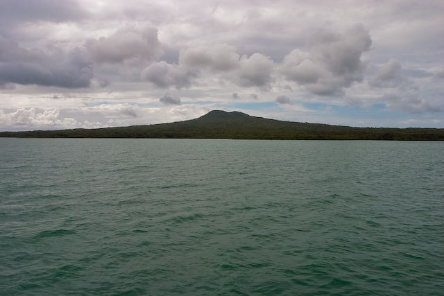
An iconic volcanic island rising symmetrically from the waters of Auckland’s Hauraki Gulf, offering wild beauty just a ferry ride from the city.
Rangitoto Island is the youngest and largest of Auckland’s volcanic cones, having emerged from the sea in a series of eruptions roughly 600 years ago. Its perfectly symmetrical silhouette is one of the most recognisable landmarks of the Auckland skyline, visible from countless beaches, suburbs and harbour viewpoints across the region.
Despite its proximity to New Zealand’s largest city, Rangitoto feels remarkably untouched. The island is a pest-free scenic reserve covered in the world’s largest pōhutukawa forest, with rugged lava fields, lava caves and hidden coastal coves. A short ferry ride from downtown Auckland delivers visitors to a landscape that feels worlds away from urban life.
Climbing to the summit rewards hikers with a sweeping 360-degree panorama across the Hauraki Gulf, the city skyline and neighbouring islands — a quintessential Auckland experience that combines natural drama with easy accessibility.
Highlights
- Iconic symmetrical volcanic cone — the youngest volcano in the Auckland field
- Summit walk with panoramic views over Auckland and the Hauraki Gulf
- Lava caves, black rock fields and the world’s largest pōhutukawa forest
- Pest-free island sanctuary with native birdlife and unique flora
- Historic WWII military installations and rustic bach (holiday hut) settlements
What to Do
- Hike the Summit Track (about 1 hour each way) to the crater rim and lookout
- Explore the lava caves with a torch — a short detour from the main track
- Take the road train tour to the summit if you prefer a relaxed visit
- Kayak from Auckland’s St Heliers or Mission Bay to the island for an adventurous arrival
- Picnic at Islington Bay or swim at Rangitoto Wharf on a calm day
Best Time to Visit
Late spring to early autumn (November to April) offers warm, dry weather ideal for hiking, with the bonus of crimson pōhutukawa blooms in December.
Getting There
Fullers360 ferries depart daily from Auckland’s downtown Ferry Terminal and reach Rangitoto in about 25 minutes. Private boats and guided kayak tours are also popular options.
Visitor Tips
- Wear sturdy shoes — the lava rock terrain is sharp and uneven
- Bring plenty of water, sunscreen and a hat; there’s no shop on the island
- Check ferry timetables carefully and don’t miss the last return sailing
- Carry a torch if you plan to explore the lava caves
- Help keep the island pest-free by checking your bag for stowaways before boarding
Nearby
- Motutapu Island (connected by causeway to Rangitoto)
- Devonport village and North Head historic reserve
- Waiheke Island vineyards
- Auckland Harbour Bridge and Viaduct waterfront
Whether you tackle the summit climb, paddle across the gulf or simply admire its silhouette from an Auckland beach, Rangitoto is an unforgettable encounter with the volcanic forces that shaped New Zealand’s largest city. Add it to your Auckland itinerary — you’ll understand why it captivates locals and travellers alike.
Location Map
Rangitoto Island, Hauraki Gulf Auckland New Zealand Read More »