travel

travel photos

Toronto Pearson International Airport (YYZ), Toronto Canada

Toronto Pearson International Airport (YYZ), Toronto Canada
Canada’s largest and busiest airport, serving as a major international hub connecting travelers to destinations worldwide.

Toronto Pearson International Airport, located in Mississauga, Ontario, is Canada’s premier aviation gateway and one of North America’s most important transportation hubs. With two main terminals and state-of-the-art facilities, Pearson handles millions of passengers annually and serves as a key connection point for domestic and international flights. The airport’s modern infrastructure, efficient operations, and strategic location make it essential to Canada’s travel and commerce landscape.

Highlights

  • Two main terminals (Terminal 1 and Terminal 3) with modern amenities and dining options
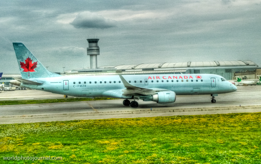
  • Hub for Air Canada, Canada’s largest airline, with extensive domestic and international routes
  • Ground transportation including express trains (UP Express), buses, and car rental services
  • Duty-free shopping and international retail outlets throughout terminals

What to Do

  • Observe aircraft operations and plane spotting from designated viewing areas
  • Explore airport terminals with contemporary architecture and design
  • Dine at various restaurants and cafes featuring local and international cuisine
  • Utilize airport lounges and amenities while waiting for flights

Best Time to Visit

Year-round, though spring and fall offer pleasant weather for ground transportation. Peak travel seasons are summer and winter holidays.

Getting There

Located 22 km northwest of downtown Toronto; accessible via UP Express train (25 minutes), airport buses, taxis, ride-sharing services, or car rental.

Visitor Tips

  • Arrive at least 2 hours before domestic flights and 3 hours before international flights
  • Use the UP Express train for quick, reliable access to downtown Toronto
  • Check real-time flight information on airport apps and digital displays
  • Explore both terminals for diverse dining and shopping experiences

Nearby

  • Downtown Toronto (25 minutes by UP Express)
  • Niagara Falls (1.5 hours drive)
  • Canada’s Wonderland theme park (30 minutes drive)
  • Toronto Islands and Lake Ontario waterfront

Toronto Pearson International Airport stands as a testament to Canada’s commitment to world-class aviation infrastructure. Whether you’re catching a flight to distant corners of the globe or simply fascinated by aircraft operations, Pearson offers an intriguing glimpse into modern air travel. Experience the energy of one of North America’s busiest aviation hubs and begin your journey to unforgettable destinations.

Location Map

Toronto Pearson International Airport (YYZ), Toronto Canada Read More »

Beth David Cemetery Aerial View, Elmont New York

Beth David Cemetery Aerial View, Elmont New York
A historic Jewish cemetery spanning hundreds of acres with distinctive organized rows and tree-lined pathways visible from above.

Beth David Cemetery is one of the largest Jewish cemeteries in the United States, located in Elmont, Long Island, New York. Established in the early 20th century, it serves as the final resting place for thousands of individuals and families from the New York metropolitan area. The cemetery spans approximately 350 acres of carefully maintained grounds, featuring organized sections, tree-lined avenues, and serene landscaping that reflects both Jewish burial traditions and American cemetery design principles. From an aerial perspective, the geometric patterns of the grave plots create a striking visual landscape, with green buffer zones and waterways interspersed throughout the grounds.

Highlights

  • 350 acres of meticulously maintained cemetery grounds with geometric plot organization
  • Tree-lined avenues and green spaces providing peaceful landscaping throughout the property
  • Distinctive waterways and drainage systems visible in aerial views
  • Historically significant as a major Jewish burial ground serving the New York area
  • Well-preserved sections representing different eras of the cemetery’s history

What to Do

  • Take a guided tour to learn about the cemetery’s history and notable burials
  • Walk the tree-lined pathways and observe the landscaping and design
  • Photograph the distinctive geometric patterns visible from elevated vantage points
  • Pay respects at family burial sites with proper cemetery etiquette
  • Explore the various sections representing different periods and communities

Best Time to Visit

Spring through fall, when the grounds are in full bloom and weather is pleasant. Summer months offer lush green landscaping, while autumn provides scenic foliage along the tree-lined pathways.

Getting There

Beth David Cemetery is located in Elmont, Long Island, accessible via the Long Island Expressway (I-495) and local roads. By car from Manhattan, it takes approximately 45 minutes to 1 hour. Public transportation options include the Long Island Rail Road (LIRR) to nearby stations.

Visitor Tips

  • Check cemetery office hours before visiting; some areas may have restricted access
  • Bring a cemetery map or use GPS to locate specific sections and burial sites
  • Dress respectfully when visiting, as this is a sacred burial ground
  • Wear comfortable walking shoes as the grounds cover extensive acreage
  • Visit during daylight hours for safety and better navigation

Nearby

  • Elmont Public Library and community centers in Elmont
  • Queens Botanical Garden in nearby Flushing, Queens
  • Forest Hills Gardens historic neighborhood
  • Local shopping and dining in Elmont and surrounding communities

Beth David Cemetery stands as a testament to Jewish heritage and community in the New York area. Whether visiting to pay respects, explore local history, or appreciate the impressive scale and organization of this historic burial ground, the cemetery offers a peaceful and meaningful experience. Its distinctive aerial landscape and carefully maintained grounds make it a unique landmark worth experiencing, reminding us of the importance of remembrance and the enduring connections between generations.

Location Map

Beth David Cemetery Aerial View, Elmont New York Read More »

Long Beach Barrier Island Aerial View, New York USA

Long Beach Barrier Island Aerial View, New York USA
A stunning aerial perspective of New York’s iconic barrier island community stretching along the Atlantic Ocean.

Long Beach is a vibrant barrier island community located on the southern coast of Long Island, New York. This captivating aerial view captures the distinctive geography of this narrow yet densely populated island, showcasing its pristine sandy beaches, residential neighborhoods, and the dramatic contrast between land and sea. The island’s unique shape and strategic location along the Atlantic coast make it one of New York’s most recognizable coastal destinations, offering both natural beauty and urban charm.

Highlights

  • Pristine Atlantic Ocean beaches with golden sand and clear blue waters
  • Distinctive narrow barrier island geography visible from above
  • Mix of residential neighborhoods, commercial areas, and natural spaces
  • Iconic boardwalk and oceanfront promenade stretching along the shore
  • Gateway location to Fire Island and other barrier island destinations

What to Do

  • Stroll the famous Long Beach Boardwalk for ocean views and local dining
  • Swim and sunbathe at the public beaches during summer months
  • Explore the historic City Hall and downtown cultural attractions
  • Enjoy water sports including surfing, paddleboarding, and kayaking
  • Visit nearby Jones Beach State Park for additional recreational activities

Best Time to Visit

Late May through September offers warm weather, calm seas, and perfect beach conditions, though spring and fall provide pleasant temperatures with fewer crowds

Getting There

Long Beach is easily accessible via the Long Island Railroad (LIRR) from Manhattan, approximately 45 minutes to 1 hour, or by car via the Southern State Parkway and Route 27

Visitor Tips

  • Visit early morning to avoid beach crowds and capture beautiful light
  • The boardwalk is best explored on foot; limited parking along the waterfront
  • Bring sun protection as the barrier island offers minimal shade
  • Summer weekends attract significant crowds; consider weekday visits
  • Check weather conditions before planning water activities

Nearby

  • Jones Beach State Park – larger state beach with additional amenities
  • Fire Island – adjacent barrier island with pristine natural areas
  • New York Aquarium – located in nearby Coney Island
  • Hempstead Lake State Park – freshwater recreation area

From the air, Long Beach reveals its true character as a remarkable feat of human habitation on a narrow strip of land between ocean and bay. Whether you’re seeking beach relaxation, water sports excitement, or simply a glimpse of how communities thrive in unique coastal environments, Long Beach offers an unforgettable New York experience that shouldn’t be missed.

Location Map

Long Beach Barrier Island Aerial View, New York USA Read More »

Rough Landing of Air Flamenco Fajardo to Culebra Island (Puerto Rico) – Aircraft N907GD 1973 Pilatus Britten-norman

Aircraft N907GD, 1973 Pilatus Britten-norman Ltd. BN-2A-26 C/N 340 – Rough Landing – Air Flamenco Flight – Fajardo to Culebra Island (Puerto Rico)

Location Map

Rough Landing of Air Flamenco Fajardo to Culebra Island (Puerto Rico) – Aircraft N907GD 1973 Pilatus Britten-norman Read More »

Video: Boeing 767-300 Landing in Toronto Pearson YYZ – LAN Chile LA532 JFK-YYZ

Video: Boeing 767-300 Landing in Toronto Pearson Airport (YYZ) – LAN Chile LA532 JFK-YYZ.

Location Map

Video: Boeing 767-300 Landing in Toronto Pearson YYZ – LAN Chile LA532 JFK-YYZ Read More »

Boeing 767-300 take off in JFK Airport – LAN Chile LA532 JFK-YYZ

Boeing 767-300 take off in JFK Airport – LAN Chile LA532 JFK-YYZ

Location Map

Boeing 767-300 take off in JFK Airport – LAN Chile LA532 JFK-YYZ Read More »

Scroll to Top