Author name: G

Wall Street, Financial District Manhattan, New York City USA

Wall Street, Financial District Manhattan, New York City USA

The world’s most famous financial artery, where towering skyscrapers and history converge in the heart of Lower Manhattan.

Wall Street is more than just a street — it is a global symbol of finance, ambition, and the relentless pulse of New York City. Tucked into the canyons of the Financial District in Lower Manhattan, this narrow corridor is flanked by historic skyscrapers, neoclassical landmarks, and the steam-laced streets that have become an iconic part of the NYC visual identity.

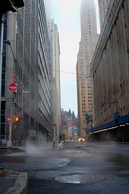
In this rare quiet moment, the bustling district feels almost deserted — steam rises from the manholes, the asphalt glistens after a light rain, and the early light filters down between the towers. It’s a side of Wall Street most visitors never see: cinematic, atmospheric, and strangely peaceful.

Whether you’re drawn by financial history, architectural grandeur, or simply the chance to walk the same streets immortalized in countless films, Wall Street offers an unforgettable urban experience.

Highlights

  • Historic skyscrapers towering over narrow Manhattan streets
  • Iconic NYC steam vents creating that signature cinematic atmosphere
  • Proximity to the New York Stock Exchange and Federal Hall
  • Architectural masterpieces from the early 20th century skyscraper boom
  • Quintessential Lower Manhattan street canyons

What to Do

  • Visit the New York Stock Exchange building and the Charging Bull statue
  • Tour Federal Hall, where George Washington was inaugurated as the first U.S. President
  • Explore Trinity Church, a Gothic Revival landmark at the head of Wall Street
  • Walk to the nearby 9/11 Memorial & Museum at the World Trade Center
  • Take a photography walk through the dramatic skyscraper canyons at dawn

Best Time to Visit

Early mornings on weekends offer the quietest, most photogenic experience, while weekdays bring the buzz of finance professionals. Spring and autumn provide the most pleasant walking weather.

Getting There

Easily accessible via the NYC subway — take the 2/3, 4/5, J/Z, or R/W trains to stations like Wall Street, Broad Street, or Fulton Street. Ferries from Staten Island and Brooklyn also dock nearby.

Visitor Tips

  • Visit early in the morning for empty streets and dramatic light through the buildings
  • Wear comfortable walking shoes — the cobblestones and uneven pavement can be tricky
  • Combine your visit with the nearby South Street Seaport and Battery Park
  • Security is tight near the NYSE, so don’t be alarmed by barriers and police presence

Nearby

  • Charging Bull and Fearless Girl statues
  • 9/11 Memorial & Museum
  • Battery Park and Statue of Liberty ferries
  • Brooklyn Bridge
  • South Street Seaport

Wall Street isn’t just a place to see — it’s a place to feel. Stand at its center on a misty morning, look up at the towers vanishing into the fog, and you’ll understand why this small stretch of Manhattan has captivated dreamers, filmmakers, and financiers for over a century.

Location Map

Wall Street, Financial District Manhattan, New York City USA Read More »

Horseshoe Falls, Niagara Falls Ontario Canada

Horseshoe Falls, Niagara Falls Ontario Canada

Witness the thunderous power and ethereal mist of one of North America’s most iconic natural wonders.

Horseshoe Falls, the largest of the three waterfalls that collectively form Niagara Falls, plunges with breathtaking force along the border between Ontario, Canada, and New York, USA. Its dramatic curved crest sends millions of gallons of water cascading every minute into the Niagara River below, creating a perpetual veil of mist that rises high into the sky.

From the Canadian side, visitors are treated to the most panoramic and awe-inspiring views of the falls, where the sheer scale of nature’s spectacle is on full display. The iconic Hornblower (formerly Maid of the Mist) boats can often be seen bravely sailing into the swirling waters at the base of the cascade, dwarfed by the towering wall of water above.

Whether shrouded in rainbow-tinted spray on a sunny afternoon or illuminated in vibrant colors after dark, Horseshoe Falls offers a sensory experience that has captivated travelers, honeymooners, and adventurers for centuries.

Highlights

  • The thundering 670-foot-wide Horseshoe Falls with its iconic curved shape
  • Constant mist clouds rising hundreds of feet into the air, visible from miles away
  • Spectacular boat tours that bring visitors face-to-face with the falls
  • Lush surrounding parkland and scenic walking promenades along the Niagara Parkway

What to Do

  • Take a Hornblower Niagara Cruise to experience the falls up close from the water
  • Visit Journey Behind the Falls to stand in tunnels carved into the bedrock behind the cascade
  • Stroll along Queen Victoria Park for postcard-perfect viewpoints and gardens
  • Watch the nightly illumination and seasonal fireworks over the falls
  • Ride the Niagara SkyWheel for panoramic aerial views of the entire falls area

Best Time to Visit

June through August offers warm weather and full attraction operations, while September and October bring fewer crowds and stunning fall foliage. Winter transforms the falls into a magical icy wonderland.

Getting There

Niagara Falls is about 90 minutes by car from Toronto Pearson International Airport via the QEW highway. Buffalo Niagara International Airport is closer (30 minutes) on the US side. VIA Rail and GO Transit provide train service from Toronto, and numerous bus tours operate daily.

Visitor Tips

  • Bring a waterproof jacket or buy a poncho — you will get wet from the mist
  • Purchase the Niagara Falls Adventure Pass for bundled savings on top attractions
  • Visit early morning or late evening to avoid the largest crowds
  • Stay overnight on the Canadian side for the best fall-view hotel rooms

Nearby

  • Niagara-on-the-Lake historic town and wineries
  • Clifton Hill entertainment district
  • Whirlpool Aero Car and Niagara Glen hiking trails
  • Skylon Tower observation deck

Standing before Horseshoe Falls, feeling the cool mist on your face and hearing the deafening roar of cascading water, is a humbling reminder of nature’s raw power and beauty. No photograph can truly capture the experience — Niagara Falls is a destination that demands to be witnessed in person, and once you do, it will stay with you forever.

Location Map

Horseshoe Falls, Niagara Falls Ontario Canada Read More »

The Cafe on Queen Street, Port Perry Ontario Canada

The Cafe on Queen Street, Port Perry Ontario Canada

A charming small-town cafe set in a heritage red-brick storefront in historic downtown Port Perry.

Tucked along the picturesque streets of downtown Port Perry, this welcoming cafe occupies a beautifully preserved Victorian-era brick building with classic green trim and a vintage Coca-Cola-style ‘Cafe’ sign. The relaxed sidewalk seating, hanging baskets bursting with pink blooms, and cheerful ‘Open’ signs make it an instantly inviting stop for locals and visitors exploring the town.

Port Perry itself is a lakeside gem on the shores of Lake Scugog, known for its 19th-century architecture, independent boutiques, and friendly community feel. The cafe captures the spirit of this town perfectly — unhurried, character-filled, and steeped in small-town Ontario charm.

Highlights

  • Historic red-brick storefront with restored Victorian details
  • Charming sidewalk seating perfect for people-watching
  • Located in the heart of Port Perry’s heritage downtown
  • Classic ice cream and coffee menu in a nostalgic setting

What to Do

  • Enjoy a coffee or homemade ice cream on the patio
  • Stroll the heritage shopping district along Queen Street
  • Walk down to the Lake Scugog waterfront and Palmer Park
  • Browse the independent boutiques and antique shops nearby

Best Time to Visit

Late spring through early autumn, when the patios are open, the flowers are blooming, and Port Perry’s lakeside ambiance shines.

Getting There

Port Perry is about a one-hour drive northeast of Toronto via Highway 407 and Highway 7A. Limited regional bus service is available, but driving is the easiest option.

Visitor Tips

  • Visit on a weekday morning to avoid weekend crowds
  • Combine your cafe stop with a walk along the Lake Scugog boardwalk
  • Check for summer street festivals and farmers’ markets in town
  • Bring a camera — the heritage architecture is wonderfully photogenic

Nearby

  • Lake Scugog and Palmer Park waterfront
  • Port Perry Town Hall 1873 theatre
  • Scugog Shores Museum Village
  • Independent shops along Queen Street

Whether you’re road-tripping through Ontario’s cottage country or seeking a slow afternoon away from the city, this little cafe in Port Perry offers exactly the kind of charming pause that makes a day memorable. Pull up a chair, order something cold, and watch small-town life go by.

Location Map

The Cafe on Queen Street, Port Perry Ontario Canada Read More »

Château Frontenac, Quebec City Canada

Château Frontenac, Quebec City Canada

A fairytale castle hotel towering over the St. Lawrence River, glowing like a jewel against the Quebec night sky.

Perched majestically atop Cap Diamant in the heart of Old Quebec, the Château Frontenac is one of the most photographed hotels in the world. With its copper turrets, soaring towers, and Châteauesque architecture, this iconic landmark looks like something pulled straight from the pages of a European fairytale — yet it stands proudly in French Canada.

Built in 1893 by the Canadian Pacific Railway and named after Louis de Buade, Comte de Frontenac, the hotel has hosted royalty, world leaders, and countless travelers for over 130 years. By night, its illuminated façade transforms into a glowing spectacle, casting a warm golden hue over the cobblestone streets of the historic district below.

A UNESCO World Heritage backdrop, the Château embodies the romance, history, and old-world charm that define Quebec City as one of North America’s most enchanting destinations.

Highlights

  • Iconic Châteauesque architecture with copper-clad turrets and steep roofs
  • Recognized as the most photographed hotel in the world
  • Stunning nighttime illumination that lights up Old Quebec
  • UNESCO World Heritage Site location in Vieux-Québec
  • Sweeping views over the St. Lawrence River from Dufferin Terrace

What to Do

  • Take a guided history tour of the Château to discover its royal guests and secrets
  • Stroll along Dufferin Terrace for panoramic river views and street performers
  • Dine at Champlain Restaurant for refined French-Canadian cuisine
  • Explore the cobblestone streets of Petit-Champlain just below the cliff
  • Enjoy afternoon tea or cocktails at the historic 1608 Bar

Best Time to Visit

Visit in winter (December–February) to see the Château blanketed in snow during Quebec’s Winter Carnival, or in autumn (September–October) for spectacular foliage along the St. Lawrence.

Getting There

Fly into Québec City Jean Lesage International Airport (YQB), about 20 minutes by taxi or shuttle. The Château is easily reached on foot from anywhere in Old Quebec, or by train via VIA Rail’s Gare du Palais station.

Visitor Tips

  • Book guided tours in advance — they fill quickly during peak season
  • Visit at dusk for the best photos as the lights come on against the twilight sky
  • Even non-guests can enjoy the lobby, terrace, and restaurants
  • Wear comfortable shoes — the surrounding streets are steep and cobblestoned

Nearby

  • Dufferin Terrace and the Governors’ Promenade
  • Quartier Petit Champlain shopping district
  • Plains of Abraham historic battlefield park
  • Place Royale and Notre-Dame-des-Victoires Church
  • Citadelle of Quebec fortress

Whether you stay the night, sip a cocktail in its grand lounge, or simply admire it from afar, the Château Frontenac is more than a hotel — it’s the soul of Quebec City. Step into its halls and you step into centuries of history, romance, and unforgettable Canadian charm.

Location Map

Château Frontenac, Quebec City Canada Read More »

Barrio Santa Cruz, Seville Spain

Barrio Santa Cruz, Seville Spain

A labyrinth of whitewashed lanes, flower-filled balconies, and Moorish charm in the heart of Andalusia.

Barrio Santa Cruz is the historic Jewish quarter of Seville, a captivating maze of narrow cobblestone streets, hidden plazas, and sun-drenched courtyards. Once home to the city’s Sephardic community, today it stands as one of the most romantic and atmospheric neighborhoods in all of Spain, where every corner reveals ornate wrought-iron balconies, colorful tiled façades, and the soft glow of antique lanterns.

Looking up between the close-set buildings, you catch glimpses of brilliant Andalusian sky framed by ochre walls and terracotta roofs. The area’s intimate scale was originally designed to provide shade from the fierce Sevillian sun, and walking through it feels like stepping back centuries. Orange trees perfume the air, fountains splash quietly in tucked-away squares, and the sound of flamenco guitar drifts from open doorways.

Bordering the magnificent Real Alcázar and Seville Cathedral, Santa Cruz is the perfect base for exploring the city’s monumental heart while losing yourself in its most enchanting backstreets.

Highlights

  • Picturesque whitewashed buildings with vibrant yellow and ochre trim
  • Ornate wrought-iron balconies and colorful ceramic tilework
  • Hidden plazas like Plaza de Doña Elvira and Plaza de los Venerables
  • Traditional Andalusian lanterns illuminating narrow alleys at night
  • Proximity to the Alcázar, Cathedral, and Giralda tower

What to Do

  • Wander aimlessly through the maze of streets and discover hidden corners
  • Visit the Hospital de los Venerables, a stunning baroque building with art collection
  • Enjoy tapas at traditional bars like Las Teresas or Bodega Santa Cruz
  • Take a flamenco show at Casa de la Memoria for an authentic cultural experience
  • Explore the Real Alcázar’s gardens, just steps from the barrio

Best Time to Visit

Spring (March to May) and autumn (September to November) offer pleasant temperatures and fewer crowds, with April bringing the famous Feria de Abril.

Getting There

Seville is served by San Pablo Airport with direct flights from across Europe. High-speed AVE trains connect from Madrid in 2.5 hours. Barrio Santa Cruz is best explored on foot from the city center.

Visitor Tips

  • Wear comfortable shoes — the cobblestone streets can be uneven
  • Visit early morning or evening to avoid crowds and harsh midday heat
  • Don’t rely on GPS; getting lost is part of the charm
  • Book restaurants in advance, especially during high season

Nearby

  • Real Alcázar of Seville
  • Seville Cathedral and Giralda
  • Plaza de España
  • Murillo Gardens
  • Archivo de Indias

Whether you’re seeking history, romance, or simply a place to lose yourself in beauty, Barrio Santa Cruz offers an unforgettable encounter with the soul of Andalusia. Step into its sunlit alleys and let Seville’s most magical neighborhood weave its timeless spell.

Location Map

Barrio Santa Cruz, Seville Spain Read More »

The Cathedral Peaks, Tibetan Plateau Tibet

The Cathedral Peaks, Tibetan Plateau Tibet

A jagged, sky-piercing ridge of weathered spires that rises from the high desert like a natural cathedral carved by wind and time.

Towering above the windswept high-altitude plains of the Tibetan Plateau, this dramatic ridge of serrated stone earns its nickname ‘The Cathedral’ through its unmistakable spire-like silhouette. Sun-bleached rock walls plunge from sharp summits down to scree slopes scattered with hardy alpine vegetation, creating a scene that feels both ancient and otherworldly.

The surrounding landscape is one of vast silence, where the only sounds are the wind racing across the plateau and the occasional clatter of loose stone. Travelers crossing this remote stretch of Tibet often pause here, struck by the sheer scale and the way light shifts across the limestone faces throughout the day.

Whether glimpsed from a passing 4×4 on the journey toward Everest Base Camp or admired from a roadside camp, the Cathedral peaks are a defining image of the raw, untamed beauty of the Tibetan highlands.

Highlights

  • Dramatic serrated ridgeline resembling a Gothic cathedral
  • Pristine high-altitude desert landscape above 4,000 meters
  • Crystal-clear Tibetan skies with sweeping cloud formations
  • Untouched wilderness with virtually no development

What to Do

  • Photograph the spires in golden hour light when shadows accentuate the jagged ridgeline
  • Hike across the scree slopes for closer views of the rock formations
  • Camp on the plateau for unforgettable stargazing under some of the clearest skies on Earth
  • Combine the visit with overland journeys to Everest Base Camp or Lhasa

Best Time to Visit

May to early October, when the high passes are clear of snow and skies are typically deep blue with minimal precipitation.

Getting There

Accessible only via overland 4×4 expedition from Lhasa or Shigatse along the Friendship Highway; permits and a licensed Tibetan guide are mandatory for foreign travelers.

Visitor Tips

  • Acclimatize for several days in Lhasa before venturing to higher elevations to avoid altitude sickness
  • Dress in layers — temperatures swing dramatically between sun and shade
  • Bring high-SPF sunscreen and UV sunglasses; the thin atmosphere intensifies sun exposure
  • Carry plenty of water and snacks, as services are extremely limited

Nearby

  • Everest Base Camp (North Side)
  • Rongbuk Monastery
  • Shigatse and Tashilhunpo Monastery
  • Friendship Highway scenic route

For travelers seeking landscapes that humble the soul, the Cathedral peaks of the Tibetan Plateau offer a glimpse into one of the planet’s last great wildernesses — a place where stone, sky, and silence converge into something truly sacred.

Location Map

The Cathedral Peaks, Tibetan Plateau Tibet Read More »

Scroll to Top